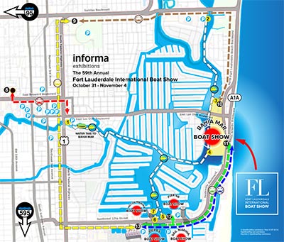
Custom Parking Map
First off if you're looking for information specific to the show please visit the official site: FLIBS.com. If you are interested in this and other maps from the show please read on.
Use The Map On Your Site:
 That's right... You are free and even encouraged to put this map on your site for non-commercial use at no charge. Non-commercial use in this case means you can't add your own graphics, deconstruct or modify it in any way including adding a marker for your business location (you are also NOT ALLOWED to use it in print without purchasing rights). If you would like to purchase rights for commercial use and/or print rights please contact Escape Key Graphics.
With that out of the way you can visit my Iframe Instructions page for simple cut and paste code instructions to add the map to your web page. The code adds not just a zoomable version of the map, but a separate map key so that visitors can zoom on the map without losing sight of the key.
GeoData Used Once Again:
Once again I am using geodata to create a map in a more conventional cartographic fashion. Maps with all of these streets and stuff require an outside source for information because just tracing it from somewhere is inefficient and usually inaccurate. The way I am doing this is efficient and accurate. I used this technique for the Palm Beach International Boat Show transit map earlier this year and it was a resounding success, so I the client requested I utilizing the same techniques here.