Transportation Map
MAPS FOR BOAT SHOWS IN MIAMI:


Maps For Boat Shows In Miami:
- Miami International Boat Show / Miami Yacht Show / Yachts Miami Beach / Miami Beach Yacht and Brokerage Show - Show Center/Primary Venue Maps: 2024 | 2023 | 2022 | 2020 | 2019 | 2018 | 2017 | 2016 | 2015 | 2014 | 2013 | 2012 | 2011
- Transit Map: 2023 | 2022 | 2020 | 2019 | 2016 | 2013
- SuperYacht Miami Show: 2020
- Miami Beach Convention Center: 2024 | 2023 | 2022 | 2013 | 2012
- Video: 2013
- Sea Isle Marina Only: 2013 | 2012
- Miamarina at Bayside Only: 2013 | 2012 | 2011
- Illustration (not a map): 2014
Miami International Boat Show Maps 2013:
Miami Beach Convention Center Map | New Yacht & Power Boat Show at Sea Isle MarinaStrictly Sail Miami at Miamarina Bayside | Miami International Boat Show Transit | Miami Beach Convention Center Parking
TRANSIT, PARKING AND TRANSPORTATION MAPS:


TRANSIT, PARKING AND TRANSPORTATION MAPS:
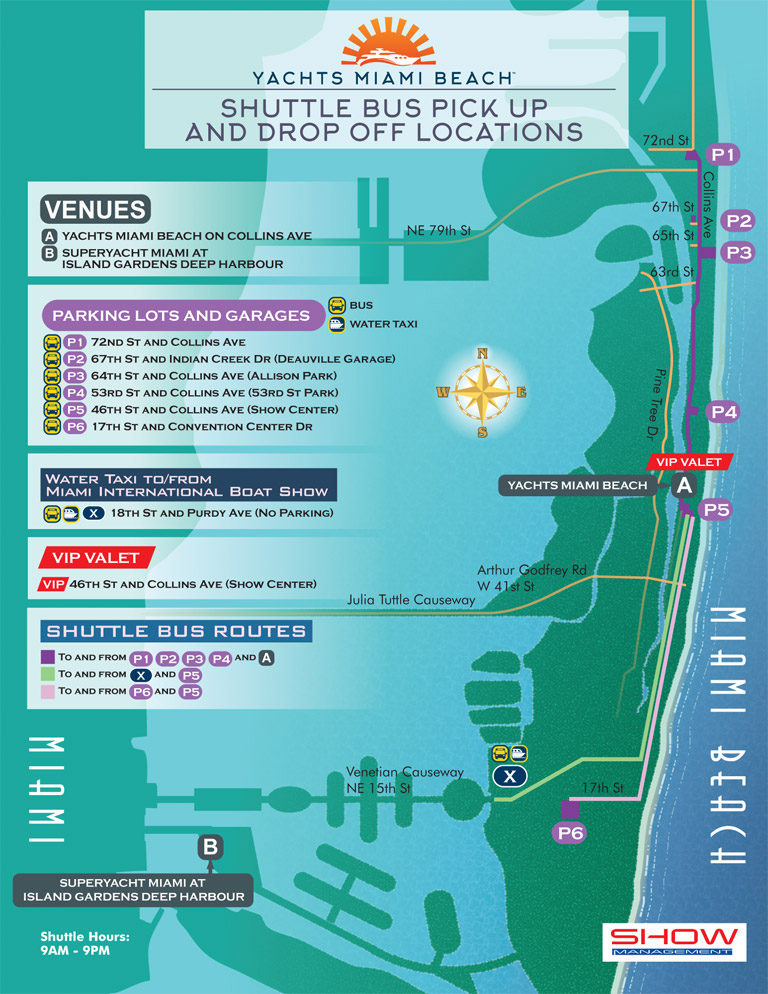
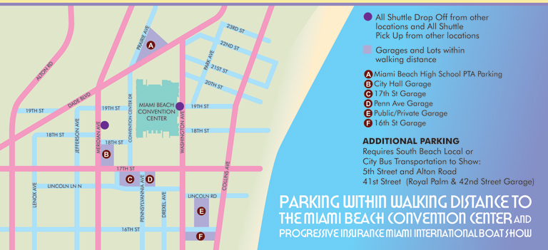
These maps are frequently familiar since the view is usually directly overhead and they can resemble a conventional street map you may have in your car (if you're nostalgic). The need for accuracy, readability and selective emphasis are paramount on these maps. I render as little or as much as the client wants and feels is helpful. The most important thing is that the user can find what they need to find... frequently while driving.
In some recent cases I am using geodata to create a map in a more conventional cartographic fashion. Maps with a high density of streets and stuff require an outside source for information because just tracing it from somewhere is far less efficient and usually at least somewhat inaccurate. I always put my own look and feel spin on it none the less.
Of course I do have cases where a 3D view has been desirable and it can certainly help to visualize the site in the real world. Especially in an area dominated by a pronounced visual landmark something that looks more real than a street map can be very helpful.
PORTFOLIOS:
- Illustration Portfolio
- Illustrated Maps Portfolio
- Fine Art
- Graphic Design Portfolio
- Motion Design
- Animated Illustrations
- Murals
- Architectural Rendering Portfolio
- Posters Portfolio
By Software Used:
By Application or Use:
- Boat Show Map Portfolio
- Resort Map Illustrations Portfolio
- Marina Maps Portfolio
- Transit, Parking and Transportation Maps Portfolio
- Town and City Maps Portfolio
- Cover Illustration Portfolio
- Vehicle Wrap & Vinyl Wrap Portfolio
- Illustrated Park Maps Portfolio
- Wayfinding Maps Portfolio
- Proposal Renderings Portfolio
- Street Art
- Real Estate Maps Portfolio