
San Diego International Boat Show in San Diego, California – Illustrated Map 2025
Client: Revel Republic
I am the illustrator and designer of this map. If you want the latest and most accurate information about attending the San Diego International Boat Show please visit their official site at SDIBS.com
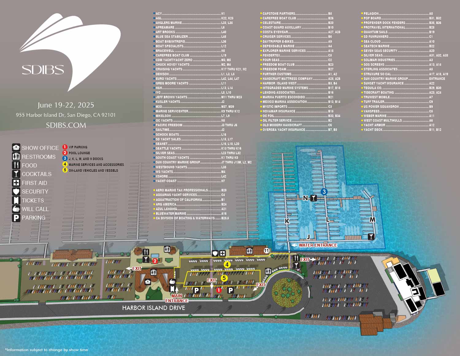
The San Diego International Boat Show (SDIBS) will be held June 19-22, 2025 at Safe Harbor Sunroad, featuring a dynamic mix of in-water and on-land exhibitions, interactive activations, and entertainment for boating enthusiasts of all kinds.
I was commissioned by Revel Republic to create an illustrated map for the event, designed to guide visitors, exhibitors, and staff through the venue with clarity and style. The site presented an interesting challenge due to its irregular layout, but this unique shape provided ideal negative space for exhibitor listings and key areas. While the map is primarily an overhead view, the addition of rich textures, realistic shadows, and subtle illustration elevates it into a polished, upmarket visual suitable for promotional and operational use.
To streamline navigation, exhibitor locations are grouped by color-coded zones, while major points of interest such as VIP parking and The Pool Lounge are numbered for easy reference. Essential facilities and amenities, including restrooms, will call, and recurring services such as food vendors, are represented with clear icons, making the map intuitive and easy to use. Building the venue as a virtual model also allows flexibility for future revisions, including changes to perspective or layout, without the need to start the illustration from scratch.
This map balances practical wayfinding with sophisticated design, helping attendees orient themselves quickly while reinforcing the premium experience of the San Diego International Boat Show.
MAPS FOR THE SAN DIEGO INTERNATIONAL BOAT SHOW:
- About The San Diego International Boat Show
- Main Map: 2026 | 2025 | 2024
MAPS FOR BOAT SHOWS IN CALIFORNIA:


EXPLORE MY WORK
- Illustration: Discover custom illustrations, book covers, illustrated maps, and architectural renderings.
- Fine Art: Browse original paintings and drawings, view the Custom Halftone Series, or check out mural projects.
- Graphic Design & Motion: See the graphic design collection, then dive into motion design and animated illustrations.
- Maps by industry: View illustrated maps tailored for boat shows, resorts, marinas, real estate, transportation, towns, parks, and wayfinding.
- More project types: Explore cover art, vehicle wraps, proposal renderings, and street art.
- Techniques & styles: Work spans vector, isometric, painting, black-and-white, GeoData, overhead maps, and halftones.
- Software expertise: Primary tools include Photoshop, Illustrator, SketchUp Pro, and InDesign, plus Premiere Pro & After Effects for motion. I am also supplementing some projects with AI.