
Map for The Newport Beach International Boat Show - proposal illustration
Client: Revel Republic
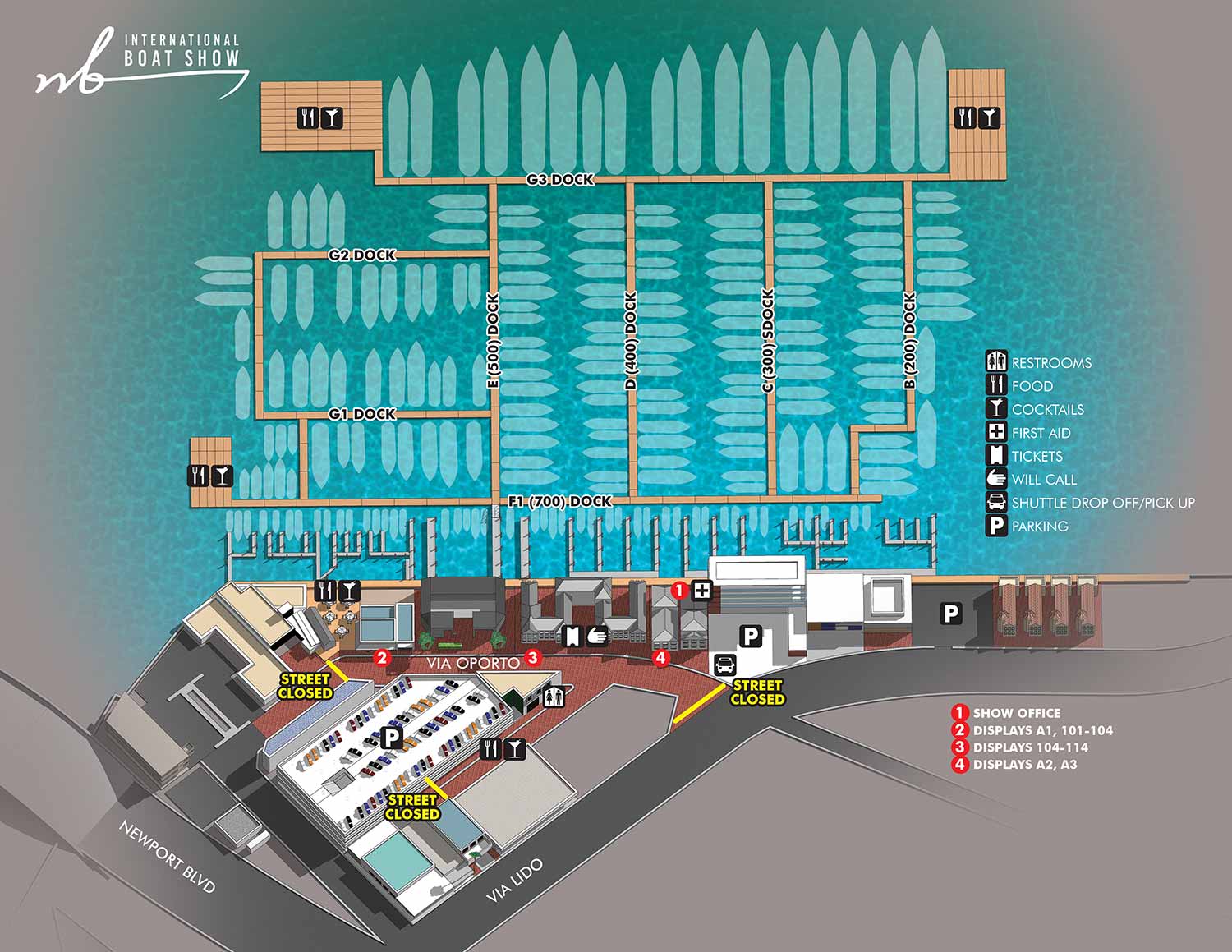
It was a true honor to contribute to the foundational planning for this event. This illustrated map was created as a key visual component for the proposal to launch the Newport Beach International Boat Show. While a show by the same name has previously been held at this venue, the new management and vision essentially represent a fresh start, making this a new event from the ground up.
I developed a three dimensional digital model specifically for this proposal, designed to serve as the core geographic asset for all future maps. This model provides significant long term advantages. It ensures that the vast majority of the visual information can be retained from year to year, allowing focus to remain solely on updating exhibit areas and layouts. This guarantees visual continuity. Furthermore, the model offers inherent versatility; the illustration can be rendered from different angles or magnifications, and it holds the potential for customization to support additional applications such as sponsorship overlays or detailed area insets.
The map was based on CAD style technical drawings supplied by the client. As with most boat shows I work on, the primary annual updates will involve changes to the floating dock configurations and some rearrangement of land based displays. From a graphic design standpoint, this will involve updating exhibitor listings and adjusting specific labels as needed.
Illustrated event maps fulfill a distinct and valuable role by enabling potential attendees to clearly visualize their experience before arrival. Rather than relying on generic stock photography, guests can examine an accurate and detailed representation of the actual event layout. These maps effectively communicate the event's scale and physical setting while delivering practical information about amenities, including restroom locations, food and beverage access, and transportation or parking options. As a result, illustrated maps function as both aesthetically pleasing graphics and genuinely useful informational and marketing resources from the earliest stages of event development.
For more examples of my cartographic work for marine events, please visit my Maps Portfolio.
This show is in Newport Beach, California so don't confuse it with The Newport International Boat Show in Newport, Rhode Island which I also do work for.
MAPS FOR THE NEWPORT BEACH INTERNATIONAL BOAT SHOW:


EXPLORE MY WORK
- Illustration: Discover custom illustrations, book covers, illustrated maps, and architectural renderings.
- Fine Art: Browse original paintings and drawings, view the Custom Halftone Series, or check out mural projects.
- Graphic Design & Motion: See the graphic design collection, then dive into motion design and animated illustrations.
- Maps by industry: View illustrated maps tailored for boat shows, resorts, marinas, real estate, transportation, towns, parks, and wayfinding.
- More project types: Explore cover art, vehicle wraps, proposal renderings, and street art.
- Techniques & styles: Work spans vector, isometric, painting, black-and-white, GeoData, overhead maps, and halftones.
- Software expertise: Primary tools include Photoshop, Illustrator, SketchUp Pro, and InDesign, plus Premiere Pro & After Effects for motion. I am also supplementing some projects with AI.