St. Petersburg Boat Show Map, 2019
Client: Informa Markets
For information on attending the Saint Petersburg Power and Sailboat Show please visit StPeteBoatShow.com
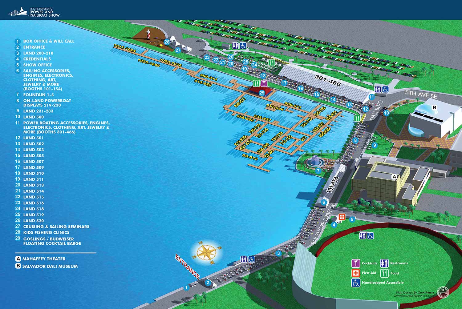
The most immediately noticeable update for the 2019 St. Petersburg Power and Sailboat Show was the new minimalist header design. While not my own creation, I found it to be a significant aesthetic improvement. This clean style would later become the standardized look across Informa's portfolio of boat shows. The established keying system, using white characters on blue dots, remained in place, as did most other core features of the map.
This year's revisions were largely routine. They included the expected alterations to floating dock configurations, adjustments to boat silhouette placements, and some minor reorganization of land based exhibits. The numerical spans identifying exhibitors on the docks were updated, and the corresponding listings in the map key were revised to reflect these changes.
A minimal need for major redesign is often a sign of a solid, effective foundation. Returning visitors typically find comfort and ease in a familiar layout. I maintain continuity by using the same three dimensional digital model as the basis for the map each year. This approach allows me to preserve the overall illustration while efficiently updating only the elements that require change.
For this show, the client typically provides either a CAD file of the venue or annotated notes. With a CAD file, I perform a detailed review to identify any discrepancies from the previous layout. For a smaller show with few changes, the client may simply provide handwritten notes directly on the previous year's map. Once the base illustration is updated, I require finalized text for any revisions to the map key and exhibitor number spans. These updates may also be provided as simple annotations if the changes are minor.
The nature of the marine event industry is inherently dynamic. Last minute adjustments are common, with new exhibitors confirming participation and sponsors altering plans close to the event date. It is standard for clients to include disclaimers noting that information is subject to change after materials are printed or published. This fluid environment is a key reason many illustrators might be hesitant to take on such projects. Successfully creating boat show maps requires a graphic artist who is accurate, efficient, and highly adaptable to evolving requirements.
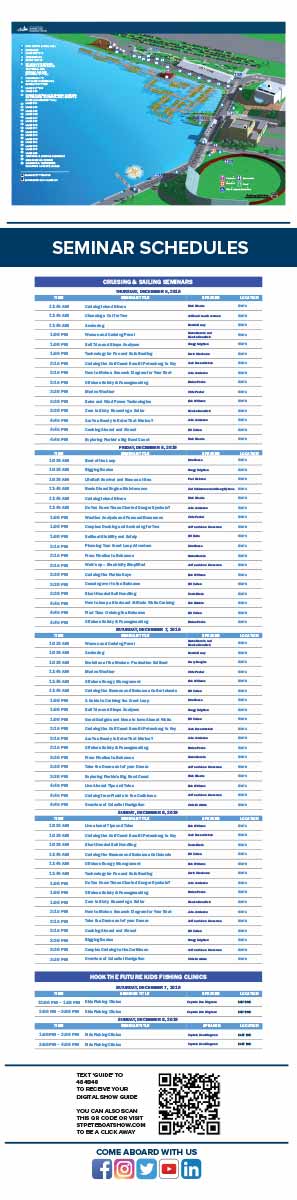
Illustrated event maps serve a unique function by allowing potential attendees to visualize their experience in advance. Rather than relying on generic stock photography, guests can examine a clear and detailed representation of the actual event layout. These maps effectively communicate the event's scale and physical setting while providing practical information about amenities, including restroom locations, food and beverage access, and transportation or parking options. As a result, illustrated maps operate as both aesthetically pleasing graphics and genuinely useful informational and marketing resources.
For more examples of my illustrative cartography for events, please visit my Maps Portfolio.
St. Petersburg Power & Sailboat Show Maps
- About St. Petersburg Power & Sailboat Show
- 2026 | 2025 | 2024 | 2023 | 2022 | 2021 | 2019 | 2018 | 2017 | 2016 | 2015 | 2014 | 2013 | 2012 | 2011
CUSTOM BOAT SHOW MAPS:


PORTFOLIOS
- Illustration Portfolio: Start here for custom illustration and book covers. You can also browse illustrated maps and architectural rendering.
- Fine Art: I offer original paintings and drawings, including my Custom Halftone Series. You will also find mural work here.
- Graphic Design & Motion: View my graphic design portfolio. After that, explore motion design and animated illustrations.
- Maps by application: I create illustrated maps for boat shows, resorts, marinas, real estate, transportation, transit and parking, towns and cities, parks, and wayfinding.
- Additional project types: I also produce cover illustration, vehicle and vinyl wraps, proposal renderings, and street art.
- Illustration methods: My techniques include vector, isometric and axonometric, painting, black and white, GeoData maps, overhead maps, and custom halftones.
- Software portfolios: I work primarily in Adobe Photoshop, Adobe Illustrator, SketchUp Pro, and Adobe InDesign. For motion projects, I use Premiere Pro and After Effects. You can watch my demo reel here.