
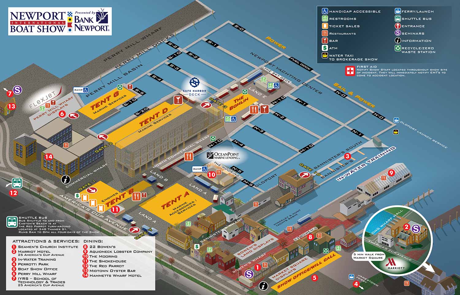
An illustrated guest map for the show, with some notable changes from previous years
Client: The Newport Exhibition Group
I'm the guy who makes these maps. If you plan on attending the show please visit the show's website to make sure you're getting all the latest information on The Newport International Boat Show at http://www.newportboatshow.com/
About the Show
The Newport International Boat Show is one of the largest and most respected boat shows in the Northeast. It takes place each September across more than seventeen acres in historic downtown Newport, Rhode Island. The show spreads across multiple interconnected sites including the Newport Yachting Center, Hammetts Hotel, Perry Mill Wharf, Bowen's Wharf, Bannisters Wharf, and Market Square. The venue is dense and the line between the show and the surrounding neighborhood is softer than at most other shows I work on.
The Changes in 2023
The 2023 map had some major changes compared to recent years.
An emphasis on labeling over keying was maintained, but a features key, specifically for Attractions & Services and Dining, was added for the first time since 2012. Graphical icons still identified facilities and some amenities.
The water was simplified to a solid blue tone with no texture. This gave the map a cleaner, more graphic look.
Exhibitor tents were reduced to footprints rather than full renderings. This made the whole map feel more diagrammatic compared to earlier versions.
The Marriott, which falls far beyond the main map bounds, was illustrated in an inset map so visitors could still see its location relative to the show.
Although these changes may seem few, they had a noticeable impact on the look and feel of the map. It became cleaner and more graphic while still serving its main purpose of helping people find their way.
Beyond these visible changes, the usual work of updating floating docks and land exhibitor placements remained the bulk of the effort. The axonometric vector illustration looking inland, which I built in 2021, continued to serve as the foundation. Without that base, the labor would have easily tripled.
Why a Map Matters
Maps like this are great wayfinding tools. They can be used for signage, printed handouts, phone apps, and websites. But that is not their full potential.
A well made map is also a marketing tool. It gives potential visitors actual information about your event before it happens. It lets them plan, imagine themselves there, and get excited. A map is visual information unique to your event. It connects people with your event in a way that lifestyle photography and flashy graphics cannot.
What I Can Do For You
If you have an event or anything else that needs a map, contact me. I have over a decade of experience doing this kind of work and I would be glad to help you take your event to the next level.
Maps For Newport International Boat Show:
- About Newport International Boat Show
- Main Map: 2026 | 2025 | 2024 | 2023 | 2022 | 2021 | 2019 | 2018 | 2017 | 2016 | 2015 | 2014 | 2013 | 2012
- Tent Details Map: 2026 | 2017 | 2016 | 2015 | 2014 | 2013 | 2012
- Video: 2012
EXPLORE MY PORTFOLIOS
- Illustration: Find custom illustration, book covers, illustrated maps, and architectural rendering.
- Fine Art: Browse original paintings and drawings, the Custom Halftone Series, and murals.
- Graphic Design & Motion: See my graphic design work, plus motion design and animated illustrations.
- Maps by industry: Illustrated maps tailored for boat shows, resorts, marinas, real estate, transit & parking, towns & cities, parks, and wayfinding.
- Other project types: Also available: cover art, vehicle & vinyl wraps, proposal renderings, and street art.
- Techniques: Explore work in vector, isometric & axonometric, painting, black & white, GeoData, overhead, and halftone styles. Recently I have also begun to use AI for some specific solutions.
- Software: Primary tools: Photoshop, Illustrator, SketchUp Pro, and InDesign. Motion work uses Premiere Pro & After Effects.