Map for the Palm Beach International Boat Show - 2021
Client: Informa Markets
For event information and all the latest maps please visit the official site of the boat show.
If you are interested in hiring me to create an original map or illustration for you please contact me.
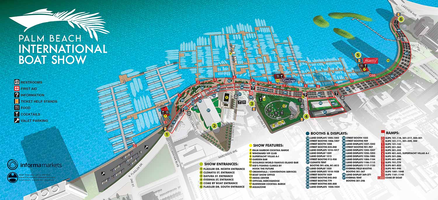
Following the necessary hiatus in 2020, the Palm Beach International Boat Show returned for 2021. The planned expansion featuring a Superyacht Village across the Intracoastal Waterway was no longer part of the layout. The show's overall footprint also contracted slightly, with the northern section of the Palm Harbor Marina's permanent docks no longer included. To accommodate the remaining elements clearly, including the essential parking lot at Palm Harbor Marina, the magnification and framing of the map remained similar to the 2019 version.
The standard annual revisions were made based on site plans provided by the client. These included updates to floating dock configurations and the placement of land based exhibitor tents. The map keys were revised to reflect the current information, while maintaining the established color coded numbered dot system and the set of graphical icons for amenities. The overall visual style and user experience remained consistent.
The need to revise only essential information each year is a testament to the effectiveness of the underlying design. This consistency builds confidence, as returning guests and exhibitors appreciate the familiar and reliable format. The nature of the events industry involves inherent fluidity, with exhibitors often finalizing their participation and sponsors making adjustments up to the last minute. This dynamic situation can be stressful for all parties involved. It underscores the necessity of working with a professional illustrator and designer who is capable of executing accurate, high speed revisions to sometimes complex illustrations and graphical systems.
Illustrated maps provide a distinct advantage as a visually appealing and informative marketing tool prior to an event. While aspirational photography has its place, an illustrated map offers potential attendees something more substantive. It presents the venue in an engaging way, conveys the scale and number of exhibitors, and clearly communicates practical information about facilities such as restrooms and accessibility. Most importantly, it helps guests clearly envision their own experience at the event, building anticipation through clarity and useful detail.
For more examples of my illustrative cartography for events, please visit my Maps Portfolio.
Maps For Palm Beach International Boat Show:
- About The Palm Beach Boat Show
- Main Map: 2026 | 2025 | 2024 | 2023 | 2022 | 2021 | 2020 | 2019 | 2018 | 2017 | 2016 | 2015 | 2014 | 2013| 2012 | 2011
- Transit & Parking Map: 2026 | 2025 | 2024 | 2023 | 2022 | 2020 | 2019 | 2018 | 2016
- Program Layout: 2026 | 2025 | 2024
- Video: 2013


PORTFOLIOS
- Illustration Portfolio: Start here for custom illustration and book covers. You can also browse illustrated maps and architectural rendering.
- Fine Art: I offer original paintings and drawings, including my Custom Halftone Series. You will also find mural work here.
- Graphic Design & Motion: View my graphic design portfolio. After that, explore motion design and animated illustrations.
- Maps by application: I create illustrated maps for boat shows, resorts, marinas, real estate, transportation, transit and parking, towns and cities, parks, and wayfinding.
- Additional project types: I also produce cover illustration, vehicle and vinyl wraps, proposal renderings, and street art.
- Illustration methods: My techniques include vector, isometric and axonometric, painting, black and white, GeoData maps, overhead maps, and custom halftones.
- Software portfolios: I work primarily in Adobe Photoshop, Adobe Illustrator, SketchUp Pro, and Adobe InDesign. For motion projects, I use Premiere Pro and After Effects.