
2024 Illustrated Map for The Saint Petersburg Power and Sailboat Show
Client: Informa Markets
For information on attending the Saint Petersburg Power and Sailboat Show please visit StPeteBoatShow.com
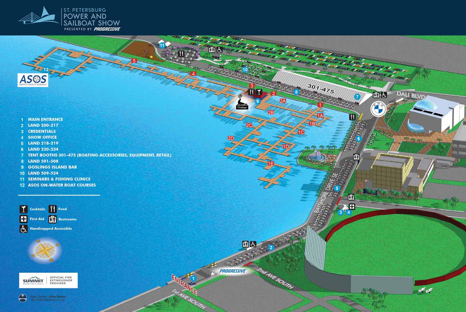
For the 2024 Saint Petersburg Power and Sailboat Show, the map design underwent a notable simplification. The color coded zones featured in the 2023 version were removed this year. The show layout itself saw substantial revisions, particularly in the arrangements of the floating docks. There were also several changes to the land based displays, especially within the Albert Whitted Playground area. While these physical layout updates were significant, the system for map keying required only minor adjustments. The established use of numbered blue dots for points of interest was retained, as was the set of graphical icons for identifying facilities and amenities, although they were simplified to black and white.
The illustration is built upon a durable three dimensional digital model, originally created for this show in 2012 and meticulously updated each season. The modeling and all structural alterations are performed in SketchUp Pro. The rendering process is handled by Kerkythea to produce the base visual. This rendered scene is then refined and prepared in Adobe Photoshop. All final graphics, the map key, and logo integration are completed in Adobe Illustrator.
Events of this scale often experience last minute changes due to exhibitor adjustments or sponsor requests. This environment necessitates an experienced, professional illustrator and designer who can manage these revisions, even major ones, with both accuracy and timely execution. A single requested change can cascade into alterations across several files, requiring proficiency in multiple software packages. The graphic professional you hire is a direct reflection of your business and its standards; they effectively become a visual representative of your brand.
Illustrated event maps allow everyone to become time travelers, offering a clear view of the future experience. While photographs of happy attendees are pleasant, they communicate little concrete information about your specific upcoming event. Illustrated maps empower potential guests to visualize themselves at the venue. They enable practical planning by showing the event's scale, the location of exhibitors, and the placement of essential facilities like food vendors and restrooms. A well executed illustrated map achieves the dual goal of being visually appealing and genuinely informative, serving as a cornerstone of effective event communication.
For more examples of my illustrative cartography, please visit my Maps Portfolio.
St. Petersburg Power & Sailboat Show Maps
- About St. Petersburg Power & Sailboat Show
- 2026 | 2025 | 2024 | 2023 | 2022 | 2021 | 2019 | 2018 | 2017 | 2016 | 2015 | 2014 | 2013 | 2012 | 2011


PORTFOLIO GALLERIES
- Illustration work: Start with custom illustration and cover design, then view illustrated maps and architectural renderings.
- Fine art: Discover original paintings and drawings, the Custom Halftone Series, and mural projects.
- Design & motion: Check out the graphic design gallery, then move on to motion graphics and animated illustration.
- Maps by sector: I produce illustrated maps for boat shows, resorts, marinas, real estate, transit & parking, towns & cities, parks, and wayfinding systems.
- More creative services: Additional offerings include cover illustration, vehicle wraps, proposal renderings, and street art.
- Artistic methods: My work spans vector art, isometric & axonometric views, traditional painting, black & white illustration, GeoData mapping, overhead perspectives, and halftone effects. Recently I have also begun to utilize AI in some cases.
- Preferred software: I rely on Photoshop, Illustrator, SketchUp Pro, and InDesign, plus Premiere Pro & After Effects for motion projects.