A Special Place for Big Cats
Client: The Wild Animal Sanctuary
Visit The Wild Animal Sanctuary website at WildAnimalSanctuary.org
The Tiger Round House is part of The Wild Animal Sanctuary in Keenesburg, Colorado. The sanctuary is a highly respected nonprofit organization devoted to rescuing animals from abusive and neglectful captive situations. They provide lifelong care in expansive, natural habitats where animals can live with others of their own kind.
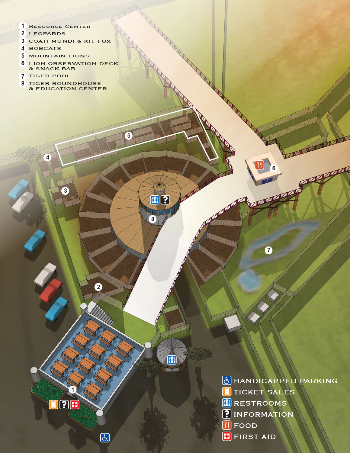
The name is slightly misleading. While it is called the Tiger Round House, the structure actually houses many species of large cats, along with a fox and some coati mundis at the time I made this map. The building provides both outdoor space and climate controlled areas for the animals. It is specifically used for the initial, intensive rehabilitation stage, helping cats adjust to open spaces, grass, and sky after years spent in confinement.
This Map
This map looks so much like an architectural rendering that I almost hesitate to call it a map. But it is a visual wayfinding tool for visitors to the sanctuary, and that makes it a map. I built it from the same 3D model I used for all the other sanctuary maps. That kept the work efficient and ensured visual continuity across the whole set.
The map includes the Round House itself and the surrounding area, including what was the welcome center at the time. That building had picnic tables on a roof deck, which the client wanted to show.
Points of interest are keyed with black numbers on white dots. Potentially recurring facilities like restrooms use simple graphical icons that anyone can recognize at a glance.
2015 Updates
This map is an update to the original version I made in 2013. The previous version had a map key for animals that had their own dedicated enclosures, marked with letters and numbers on yellow dots. It also used a granular keying system for individual enclosures. Over time, it became clear that animals needed to be moved more frequently than initially expected. That made the detailed keying impractical to maintain.
For the 2015 update, I eliminated those elements to reduce the need for constant revisions. The map is now more stable and requires less frequent updating, which works better for the sanctuary's needs. I also removed some of the translucent architectural elements that were necessary in the first version to show obscured enclosures. The current version is cleaner and simpler.
Where the Map Is Used
This map pulls double duty. It is used on signage around the sanctuary to help visitors find their way. It also appears in print materials and online, serving a marketing function by giving potential visitors a preview of what they will see.
Your Project
If you need similar work for a sanctuary, a park, a refuge, or any other venue that requires clear, thoughtful, and visually engaging maps, contact me. I have done this work before and I would be glad to do it for you.
2017 Wild Animal Sanctuary Main Map
2015 Wild Animal Sanctuary Main Map | 2015 Tiger Roundhouse
2015 Mile Into The Wild | 2015 Bolivian Lion House
2013 Wild Animal Sanctuary Main Map | 2013 Tiger Roundhouse
2013 Mile Into The Wild | 2013 Bolivian Lion House


