Event Transportation Map - Miami Yacht Show 2019
Client: Informa Markets
For official information on the 2019 Miami Yacht Show visit MiamiYachtShow.com
MAP KEY |
|
|||
 METROMOVER OMNI LOOP
 SHUTTLE BUS ROUTE
This is the web version of the map. This level of detail was developed in accordance with the client's specific request.
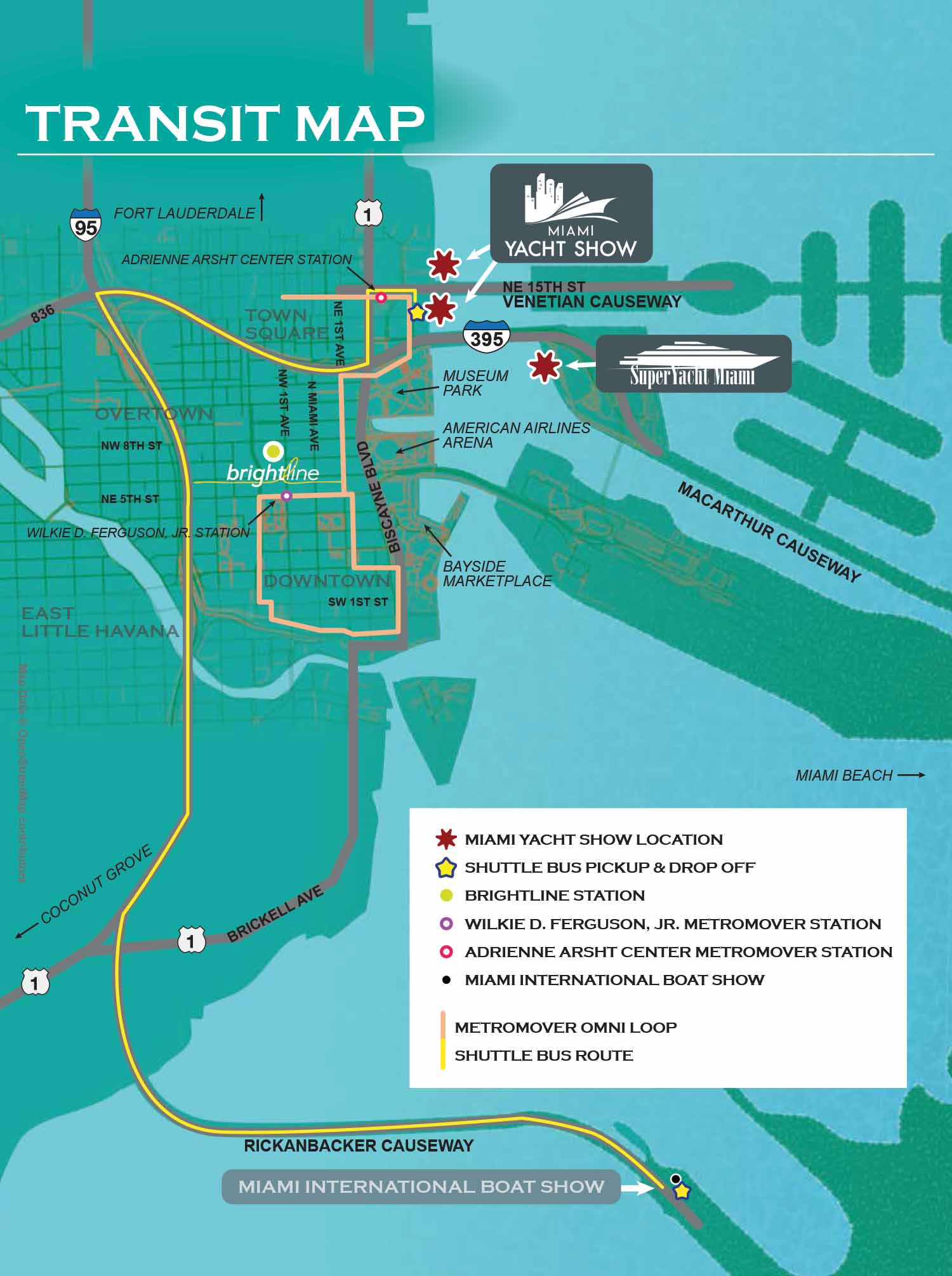
This transit map was created for the 2019 Miami Yacht Show, serving as a comprehensive navigational tool across multiple platforms. It was utilized for web based planning, printed within the official event program, and adapted for onsite signage. The map is an overhead, vector based graphic that integrates detailed open source geographic data of the downtown Miami street network. Upon this base, the relevant public and private transit options are clearly overlaid, including keyed shuttle bus routes and Metromover lines to assist attendees in moving between locations.
The design employs a systematic key to identify essential destinations. Show venues are marked with distinctive star icons. Important transit nodes, including shuttle bus stops, the Brightline Station, the Wilkie D. Ferguson Jr. Metromover station, the Adrienne Arsht Center Metromover station, and the Miami International Boat Show location, are all indicated with a coordinated system of colored dots. This approach was intended to consolidate complex travel information into a single, functional reference.
For other examples of my transportation and venue maps, which reflect my standard approach to clear, user focused design, please visit my Graphic Design portfolio.
Maps For Boat Shows In Miami:
- About Miami Boat Shows
- Miami International Boat Show / Miami Yacht Show / Yachts Miami Beach / Miami Beach Yacht and Brokerage Show - Show Center/Primary Venue Maps: 2026 | 2025 | 2024 | 2023 | 2022 | 2020 | 2019 | 2018 | 2017 | 2016 | 2015 | 2014 | 2013 | 2012 | 2011
- Transportation Map: 2026 | 2025 | 2024 | 2023 | 2022 | 2020 | 2019 | 2016 | 2013 | 2012
- Program Layout: 2026 | 2025 | 2024 | 2023 | 2022
- Yacht Haven Grande at Island Gardens: 2026 | 2022 | 2020 | 2016
- Miami Beach Convention Center: 2026 | 2025 | 2024 | 2023 | 2022 | 2013 | 2012
- Sea Isle Marina Only: 2013 | 2012
- Miamarina at Bayside Only: 2013 | 2012 | 2011
- Bayfront Park: 2015
- Museum Park Marina: 2025 | 2024 | 2023 | 2022
- Illustration (not a map): 2014
- Video: 2013
Which Miami Boat Show is this?:
Here is all you need to know... I have been making maps for boat shows in Miami since 2011 and in that time a lot has changed. There have been multiple simultaneous shows, show names have changed and now shows have merged. The assorted show titles used have been Miami International Boat Show, Miami Yacht Show, Yachts Miami Beach, Miami Beach Yacht and Brokerage Show and this doesn't include subsections of the shows like Sea Isle Marina, Museum Park Marina and Strictly Sail Miami at Miamarina Bayside. These shows have been managed by different, sometimes competing, management companies. At some point I have been commissioned to make maps for all of them. I'm not going to try to sort this into a comprehensible timeline or anything like that.
I've endeavored to make the maps easy to find but you may find some hidden gems on my site if you dig. Please enjoy these maps for what they are without getting too distracted by the sequence or sponsors/management companies etc.
Miami International Boat Show:
I have worked on illustrated maps and wayfinding graphics for the Miami International Boat Show (also known as MIBS) for many years, supporting one of the largest and most complex boat shows in the world. The show spans multiple waterfront venues across Miami and Miami Beach, including convention spaces, marinas, and on water exhibition areas. This scale presents unique challenges, and clear navigation is essential for both visitors and exhibitors. My role has been to translate that complexity into maps that are easy to understand while still feeling polished, professional, and appropriate for a premier international event.
Each year the Miami International Boat Show evolves. Dock layouts shift, exhibitor locations change, venues are added or removed, and sponsorship requirements are updated. I routinely revise and rebuild maps to reflect these changes accurately, often under tight deadlines. My approach emphasizes a strong visual hierarchy that allows guests to orient themselves quickly, identify major zones, and then locate specific docks, tents, amenities, and points of interest. This clarity helps reduce confusion and improves the overall guest experience across all show locations.
The illustrated maps I create for the Miami International Boat Show are used in a wide range of formats, including print programs, signage, exhibitor materials, and digital platforms. I rely on consistent systems such as numbered keying for primary destinations and icon based symbols for recurring amenities like restrooms, food areas, transportation, and services. This method minimizes visual clutter and ensures that information remains legible even in dense, information rich environments.
Large scale marine events like the Miami International Boat Show require a careful balance between accuracy, usability, and visual appeal. My experience with boat shows, marinas, and waterfront venues allows me to design maps that serve practical navigation needs while also reinforcing the upscale branding of the event. For organizers, sponsors, and exhibitors, a well designed illustrated map becomes an essential tool that supports crowd flow, improves communication, and enhances the overall perception of the show.