Illustrated Map of the SuperYacht Miami Show
Illustration and Graphic Design by John Potter - Escape Key Graphics
Client: Informa Markets
For information about the SuperYacht Miami Show visit MiamiYachtShow.com
Client: Informa Markets
For information about the SuperYacht Miami Show visit MiamiYachtShow.com
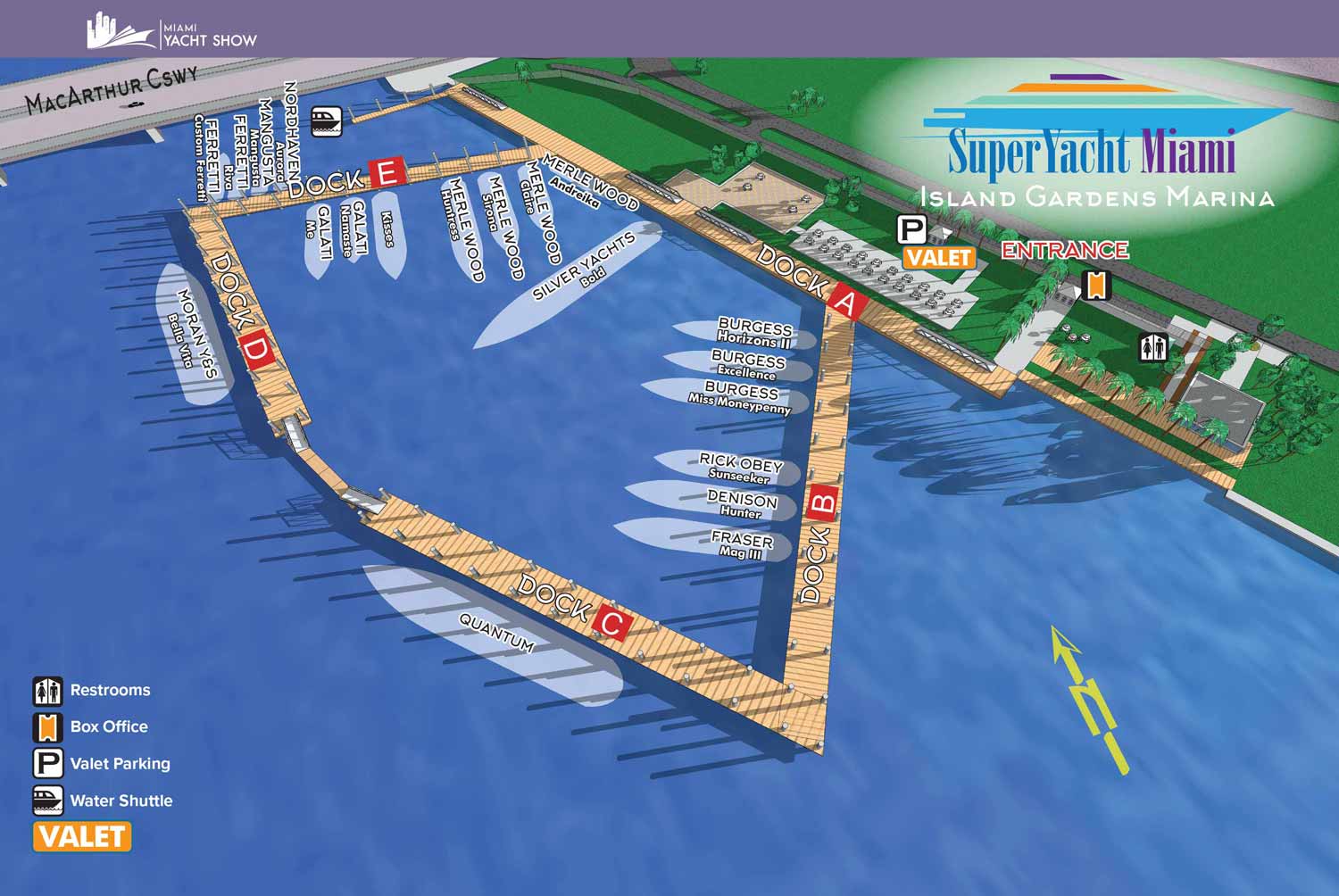
This map is for the Superyacht Miami Show on Watson Island, often known as Yacht Haven Grande at Island Gardens. This is a small but might show connected to the Miami International Boat Show just a short distance away via boat or MacArthur Causeway. This show features a select few super luxurious vessels.
This map is mostly labeled including boat names and dock letters, but there are icons keyed to identify amenities. The illustration aspect of this map is rendered from the same digital three dimensional model used to render the Miami International Boat Show's venues at Venetian Marina and One Herald Plaza.
EXAMPLES OF MAPS CREATED FOR MIAMI BOAT SHOWS:

Miami International Boat Show 2026

Miami International Boat Show 2025

Miami Yacht Show 2020

Convention Center Map

Sea Isle Marina Map

Miami Transit Map

Show Proposal Rendering

Yacht Haven Grande Miami

Bayside Miamarina Map

Miami Show Map

Transportation & Parking Map

Miami Beach Convention Center

Pride Park Map
Maps For Boat Shows In Miami:
- About Miami Boat Shows
- Miami International Boat Show / Miami Yacht Show / Yachts Miami Beach / Miami Beach Yacht and Brokerage Show - Show Center/Primary Venue Maps: 2026 | 2025 | 2024 | 2023 | 2022 | 2020 | 2019 | 2018 | 2017 | 2016 | 2015 | 2014 | 2013 | 2012 | 2011
- Transportation Map: 2026 | 2025 | 2024 | 2023 | 2022 | 2020 | 2019 | 2016 | 2013 | 2012
- Program Layout: 2026 | 2025 | 2024 | 2023 | 2022
- Yacht Haven Grande at Island Gardens: 2026 | 2022 | 2020 | 2016
- Miami Beach Convention Center: 2026 | 2025 | 2024 | 2023 | 2022 | 2013 | 2012
- Sea Isle Marina Only: 2013 | 2012
- Miamarina at Bayside Only: 2013 | 2012 | 2011
- Bayfront Park: 2015
- Museum Park Marina: 2025 | 2024 | 2023 | 2022
- Illustration (not a map): 2014
- Video: 2013

Fort Lauderdale International Boat Show Map
Miami International Boat Show 2026

Newport Beach International Boat Show Map

Newport International Boat Show Map

San Diego International Boat Show Map

Sarasota Boat Show Map

Windy City Boat & Yacht Show Map

Boat Show Map

A South American Boat Show Map

Boat Show Illustrated Map

Chicago International Boat Show Map

St. Pete Boat Show Map

Convention Center Map

Transportation Map Using GeoData
Transportation & Parking Map

Illustrated Map of Marinas
Convention Center Map
Yacht Haven Grande Miami
Marina Map
Transit Map
Show Proposal Rendering

Yacht Club Map
Miami International Boat Show 2025

Transportation & Parking Map
Miami Beach Convention Center

PBIBS SYBAss Map
PORTFOLIOS
- Illustration Portfolio: Start here for custom illustration and book covers. You can also browse illustrated maps and architectural rendering.
- Fine Art: I offer original paintings and drawings, including my Custom Halftone Series. You will also find mural work here.
- Graphic Design & Motion: View my graphic design portfolio. After that, explore motion design and animated illustrations.
- Maps by application: I create illustrated maps for boat shows, resorts, marinas, real estate, transportation, transit and parking, towns and cities, parks, and wayfinding.
- Additional project types: I also produce cover illustration, vehicle and vinyl wraps, proposal renderings, and street art.
- Illustration methods: My techniques include vector, isometric and axonometric, painting, black and white, GeoData maps, overhead maps, and custom halftones.
- Software portfolios: I work primarily in Adobe Photoshop, Adobe Illustrator, SketchUp Pro, and Adobe InDesign. For motion projects, I use Premiere Pro and After Effects.