Fort Lauderdale International Boat Show 2020 - Parking and Transit Map
Client: Informa Markets
For more (and more up to date) information about the 2020 Fort Lauderdale International Boat Show visit their official site at FLIBS.com.
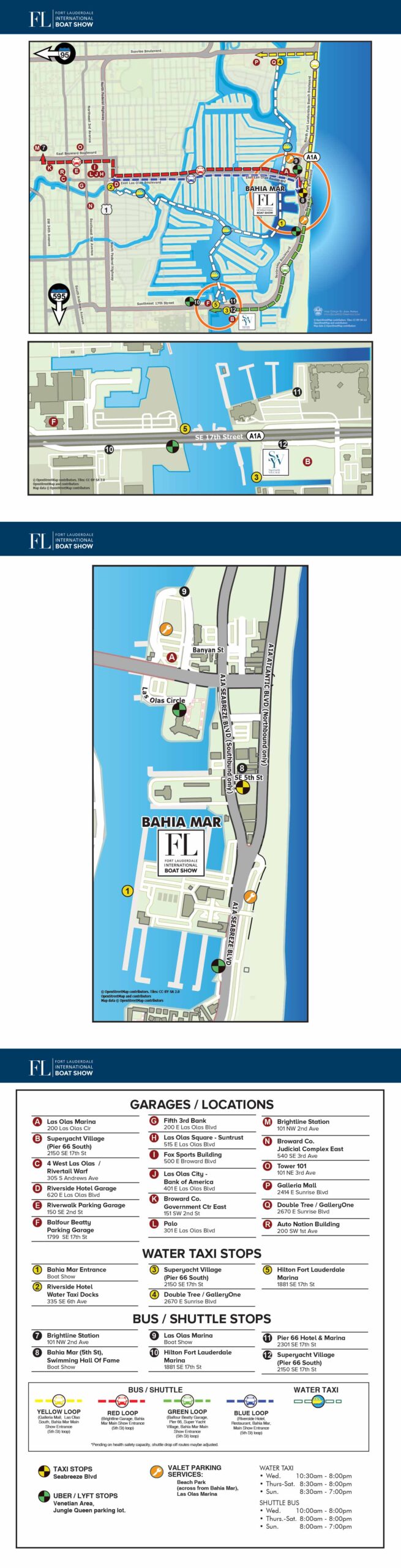
The 2020 Fort Lauderdale International Boat Show transit map represents a pivotal year in the design's evolution. A key internal realization was that previous versions had become overly dense with information, which impacted their immediate readability. Acknowledging this challenge was a necessary and positive first step, creating a shared goal to seek a more effective solution.
The approach taken to address the complexity was to introduce two inset maps. The rationale was that specific areas on the main map contained a high concentration of details, such as clustered transit stops. By providing enlarged views of these zones, the individual elements would become more legible. While this technical solution did improve readability within the insets, the overall experience remained challenging. The primary map retained its high information density, and requiring users to consult multiple panels to understand a single transit system introduced a level of inconvenience. This experience provided valuable insight, demonstrating that adding supplemental graphics was not the most streamlined solution for the core issue.
The map continued to consolidate a wide array of information. Parking locations were marked with keyed maroon dots, water taxi stops with numbered yellow dots, and bus stops with black dots. The routes for water taxis and buses were indicated with colored paths and matching icons, a combination that contributed to the overall visual complexity. While the map successfully presented a broad overview of parking facility locations, its scale meant it could not provide specific routing details, which limited its utility for detailed trip planning.
Despite its shortcomings, the 2020 edition was a constructive step forward. It operated on a framework that had clear potential, and the newly established openness to improvement was the most critical development. Throughout the process, my professional suggestions centered on two core principles: either significantly reducing the information presented on a single map or creating distinct, purpose built maps for different attendee needs, such as separating parking guidance from transit route information. The experience underscored that a comprehensive street map is highly useful for parking, while for transportation, clarity on pickup and drop off points is paramount, with detailed route graphics being secondary. These lessons were instrumental in informing the more successful and user focused design that was realized for the show's return in 2022.


MAPS FOR BOAT SHOWS IN FORT LAUDERDALE:


Fort Lauderdale International Boat Show Maps:
- About Fort Lauderdale International Boat Show
- Bahia Mar, Swimming Hall of Fame & Las Olas Marina Maps: 2025 | 2024 | 2023 | 2022 | 2020 | 2019 | 2018 | 2017 | 2016 | 2015 | 2014 | 2013 | 2012 | 2011 | 2010
- Parking and Transportation Maps: 2025 | 2024 | 2023 | 2022 | 2020 | 2019 | 2018 | 2015 Bus | 2015 Water Taxi | 2014 | 2013 | 2012 | 2011
- Broward County Convention Center Maps: 2025 | 2024 | 2023 | 2022 | 2017 Sailfish Pavilion | 2017 | 2016 Sailfish Pavilion | 2016 | 2015 Sailfish Pavilion | 2015 | 2014 Sailfish Pavilion | 2014 | 2013 Sailfish Pavilion | 2013 | 2012 | 2011 | 2010
- Marinas Maps: 2025 | 2024 | 2023 | 2022 | 2019 | 2016
- Program Layouts: 2025 | 2024 | 2023 | 2022
- Signs: 2013 looking north | 2013 Yachting Tent
- Video: 2013 54th Annual
- Illustrations (not maps): 2014A | 2014B
PORTFOLIOS
- Illustration Portfolio: Start here for custom illustration and book covers. You can also browse illustrated maps and architectural rendering.
- Fine Art: I offer original paintings and drawings, including my Custom Halftone Series. You will also find mural work here.
- Graphic Design & Motion: View my graphic design portfolio. After that, explore motion design and animated illustrations.
- Maps by application: I create illustrated maps for boat shows, resorts, marinas, real estate, transportation, transit and parking, towns and cities, parks, and wayfinding.
- Additional project types: I also produce cover illustration, vehicle and vinyl wraps, proposal renderings, and street art.
- Illustration methods: My techniques include vector, isometric and axonometric, painting, black and white, GeoData maps, overhead maps, and custom halftones.
- Software portfolios: I work primarily in Adobe Photoshop, Adobe Illustrator, SketchUp Pro, and Adobe InDesign. For motion projects, I use Premiere Pro and After Effects.