Illustrated Map For the World's Biggest Boat Show
Client: Informa Markets
For information about the Fort Lauderdale International Boat Show visit FLIBS.com
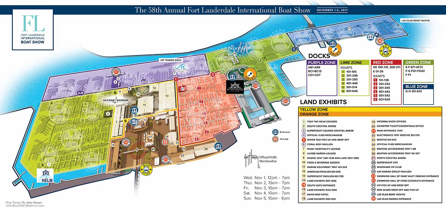
For the 2017 Fort Lauderdale International Boat Show, I continued my long standing role updating the illustrated site map covering Bahia Mar, Las Olas Marina, and the International Swimming Hall of Fame. This map serves as a primary navigation tool for one of the largest in water boat shows in the world, guiding thousands of visitors through a complex, multi venue waterfront environment.
Each year, the map requires careful revision to reflect changes in the show layout. The 2017 edition involved extensive updates to dock configurations, exhibitor locations, hospitality tents, and access points. Sponsor logos were reviewed and repositioned as needed to ensure accurate placement and consistent visibility throughout the map.
A major design shift in 2017 focused on increased visual clarity through a more minimalist approach. Much of the surrounding city context, including nearby beach areas and non show buildings, was intentionally removed. The introduction of generous white space resulted in a cleaner, more focused presentation that emphasized the official show footprint. At the same time, colored zones were introduced to shift navigation away from relying solely on individual docks or points of interest. This broader area based system made it easier for visitors to quickly understand where they were within the show and how to reach their destination.
The map maintains the Fort Lauderdale International Boat Show’s established color zone system, which is essential for managing an event of this size. Color coding allows attendees to orient themselves quickly by identifying general areas before narrowing their focus to specific docks or exhibitor sections. This layered navigation approach supports first time visitors while remaining intuitive for returning attendees, exhibitors, and event staff.
To further improve readability, docks are labeled with clear letter identifiers, land based features are keyed numerically, and shared amenities such as restrooms, services, and transportation points are indicated using a consistent icon system. These design choices ensure the map performs effectively across multiple formats, including printed show guides, large format signage, mobile devices, and digital platforms. This project demonstrates the value of custom illustrated maps as both essential wayfinding tools and strong visual assets for large scale marine events.
Fort Lauderdale International Boat Show Maps:
- About Fort Lauderdale International Boat Show
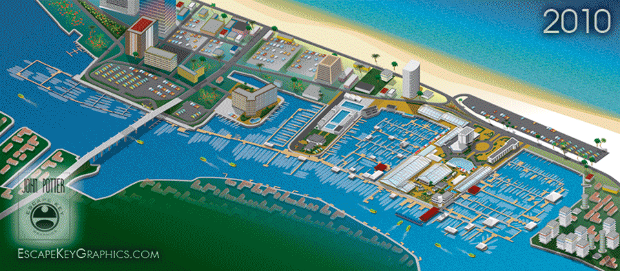
- Bahia Mar, Swimming Hall of Fame & Las Olas Marina Maps: 2025 | 2024 | 2023 | 2022 | 2020 | 2019 | 2018 | 2017 | 2016 | 2015 | 2014 | 2013 | 2012 | 2011 | 2010
- Parking and Transportation Maps: 2025 | 2024 | 2023 | 2022 | 2020 | 2019 | 2018 | 2015 Bus | 2015 Water Taxi | 2014 | 2013 | 2012 | 2011
- Broward County Convention Center Maps: 2025 | 2024 | 2023 | 2022 | 2017 Sailfish Pavilion | 2017 | 2016 Sailfish Pavilion | 2016 | 2015 Sailfish Pavilion | 2015 | 2014 Sailfish Pavilion | 2014 | 2013 Sailfish Pavilion | 2013 | 2012 | 2011 | 2010
- Marinas Maps: 2025 | 2024 | 2023 | 2022 | 2019 | 2016
- Program Layouts: 2025 | 2024 | 2023 | 2022
- Signs: 2013 looking north | 2013 Yachting Tent
- Video: 2013 54th Annual
- Illustrations (not maps): 2014A | 2014B


BOAT SHOW MAPS ARTICLE - SOUTHERN BOATING MAGAZINE 2016:
"Navigating Miami’s multiple venues is easier when you use a map. If you’re at Yachts Miami Beach – formerly The Miami Yacht and Brokerage Show – the man behind those maps is John Potter of Escape Key Graphics, who created his first boat show map for the 201 Fort Lauderdale Int’l. Boat Show. It wasn't long before the creative concept spread. Less intimidating than site plans and more easier to follow than an aerial photography, Potter’s maps now grace the Stuart Boat Show, St. Petersburg Power & Sailboat Show in Florida and International Boat Shows like Newport, Palm Beach and Panama. His work on these shows frequently extends to many maps such as detailed area maps and transit maps. Potter’s maps can also be seen beyond the yachting industry in theme parks, resorts, wildlife sanctuaries, municipalities, campuses and gardens including Flamingo Gardens, Dinosaur World parks or The Dover International Speedway."
ADDENDUM:
I am presently responsible for illustrated maps for The Chicago International Boat Show, The Fort Lauderdale International Boat Show, The Miami International Boat Show, The Newport International Boat Show, The Newport Beach International Boat Show, The San Diego International Boat Show, The Windy City Boat & Yacht Show, The Palm Beach International Boat Show, The Suncoast Boat Show and the The Saint Petersburg Power and Sailboat Show.
There is a directory in my Boat Show Map Portfolio
PORTFOLIOS
- Illustration Portfolio: Start here for custom illustration and book covers. You can also browse illustrated maps and architectural rendering.
- Fine Art: I offer original paintings and drawings, including my Custom Halftone Series. You will also find mural work here.
- Graphic Design & Motion: View my graphic design portfolio. After that, explore motion design and animated illustrations.
- Maps by application: I create illustrated maps for boat shows, resorts, marinas, real estate, transportation, transit and parking, towns and cities, parks, and wayfinding.
- Additional project types: I also produce cover illustration, vehicle and vinyl wraps, proposal renderings, and street art.
- Illustration methods: My techniques include vector, isometric and axonometric, painting, black and white, GeoData maps, overhead maps, and custom halftones.
- Software portfolios: I work primarily in Adobe Photoshop, Adobe Illustrator, SketchUp Pro, and Adobe InDesign. For motion projects, I use Premiere Pro and After Effects.