Fort Lauderdale International Boat Show Transit Map
Client: Show Management
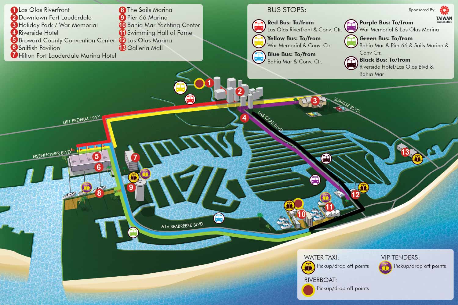
This transit map was designed as a key navigational tool for the Fort Lauderdale International Boat Show, a multi venue event requiring clear guidance for attendee movement. The map changed very little from the previous year's edition, with only minor rearrangements to menu elements while the core content and keying systems were retained. This consistency is intentional, as it provides returning visitors with a familiar and reliable resource. Its primary function is to communicate the connections between the event's dispersed venues effectively, prioritizing intuitive wayfinding and logical flow over strict adherence to geographical scale. The result is a practical, purpose built guide to the show's entire transit network.
The map employs a distinct illustrative style to facilitate quick recognition and ease of use. Important venues and area landmarks are depicted with stylized artwork, creating immediate visual cues that help users orient themselves at a glance. To organize the various transportation options clearly, a color coding system distinguishes the different shuttle routes. Each color corresponds to a specific service, with a clear map key positioned in the upper left corner for instant reference. This system allows attendees to plan their journey between locations efficiently.
Additional transit methods are integrated with equal clarity. Water taxi stops are highlighted with a dedicated set of icons, explained in a separate key located in the lower left section of the map. Major destinations are marked with numbered red dots, accompanied by a corresponding numerical list in the lower right for quick look up. To provide general orientation, the most essential roadways are labeled directly on the illustration itself. This layered approach to information ensures that all critical travel details are accessible without overwhelming the viewer.
This project exemplifies how tailored illustration and thoughtful graphic design can transform complex logistical systems into an accessible and user friendly experience. By integrating a straightforward color coded framework with engaging and clear artwork, the map successfully demystifies transportation choices for thousands of visitors. It contributes directly to a more efficient, less stressful, and ultimately more positive event experience, functioning as an essential piece of the show's operational infrastructure.
Fort Lauderdale International Boat Show Maps:
- About Fort Lauderdale International Boat Show
- Bahia Mar, Swimming Hall of Fame & Las Olas Marina Maps: 2025 | 2024 | 2023 | 2022 | 2020 | 2019 | 2018 | 2017 | 2016 | 2015 | 2014 | 2013 | 2012 | 2011 | 2010
- Parking and Transportation Maps: 2025 | 2024 | 2023 | 2022 | 2020 | 2019 | 2018 | 2015 Bus | 2015 Water Taxi | 2014 | 2013 | 2012 | 2011
- Broward County Convention Center Maps: 2025 | 2024 | 2023 | 2022 | 2017 Sailfish Pavilion | 2017 | 2016 Sailfish Pavilion | 2016 | 2015 Sailfish Pavilion | 2015 | 2014 Sailfish Pavilion | 2014 | 2013 Sailfish Pavilion | 2013 | 2012 | 2011 | 2010
- Marinas Maps: 2025 | 2024 | 2023 | 2022 | 2019 | 2016
- Program Layouts: 2025 | 2024 | 2023 | 2022
- Signs: 2013 looking north | 2013 Yachting Tent
- Video: 2013 54th Annual
- Illustrations (not maps): 2014A | 2014B


