
Illustrated Overhead Marina Map
Client: Tingdene Marinas & Boat Sales
For information on Holy Loch Marina please visit TingdeneBoating.com.
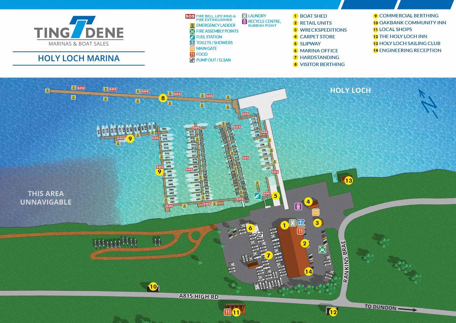
A Coastal Marina with Easy Access
Holy Loch Marina sits within the scenic Cowal Peninsula in Argyll, Scotland, offering boaters a coastal haven that combines tranquility with convenience. Located just twenty minutes by ferry from Gourock and less than an hour from Glasgow, the marina provides an ideal starting point for exploring the Upper Firth of Clyde. As Tingdene’s first Scottish location and its only coastal marina, Holy Loch Marina accommodates both short term visitors and long term residents with full service facilities and easy access to local town amenities.
A Milestone Project for Escape Key Graphics
For the illustrated map of Holy Loch Marina, I followed the same general approach I have used for other Tingdene marina maps to maintain consistency across their properties. That said, this project carries special significance for me and for Tingdene, as it marks our first collaboration in Scotland. While I recognize this milestone is largely symbolic, I take genuine pride in the fact that this represents the ninth country (that I can think of) where my work as Escape Key Graphics has been utilized (Have a look at where I've done work). As with previous projects, I had the pleasure of working with the capable staff at Tingdene headquarters in Wellingborough, England, whose professionalism continues to make each assignment rewarding.
A Clear Overhead View for Easy Orientation
Escape Key Graphics was commissioned to produce an illustrated map of Holy Loch Marina from an overhead perspective. This view enables visitors to quickly grasp the layout of the marina, including the arrangement of berths, buildings, and essential facilities. Each slip and key feature is clearly labeled, supporting intuitive wayfinding while preserving a polished and professional aesthetic that reflects the quality of the marina itself.
A Versatile Tool for Marketing and Navigation
The illustrated map functions as a versatile resource for both marketing and practical navigation. It appears across multiple platforms, including the marina website, printed brochures, and on site signage, helping to orient guests as they arrive. By blending precise spatial information with carefully crafted illustration, the map improves the visitor experience, supports efficient marina operations, and serves as an effective tool for attracting new holidaymakers and visiting boaters who expect a high standard of service and presentation at their chosen destination.


WORK FOR TINGDENE - COMBINED MARINA AND RESIDENTIAL PARK MAPS:


BROWSE MY WORK
- Illustration: Browse custom illustrations, book cover art, illustrated maps, and architectural renderings.
- Fine art: View original paintings and drawings, the Custom Halftone Series, and mural commissions.
- Graphic design & motion: See design projects, then watch motion reels and animated pieces.
- Maps by use case: Explore illustrated maps created for boat shows, resorts, marinas, real estate, transportation & parking, cities & towns, parks, and wayfinding.
- Specialty projects: Also check out cover design, vinyl & vehicle wraps, proposal renderings, and street art.
- Style & technique: Discover vector, isometric, painterly, monochrome, data-driven, bird's-eye, and halftone approaches.
- Tools I use: Everyday software includes Photoshop, Illustrator, SketchUp, and InDesign; motion work relies on Premiere & After Effects. Recently I have begun some work using AI as well.