
Illustrated Overhead Marina and Residential Map
Client: Tingdene Marinas & Boat Sales UK
For information on Waveney Marina please visit TingdeneBoating.com/inland-marinas-uk/waveney/
For information on Waveney residential homes please visit TingdeneLifestyleParks.co.uk/for-sale/category/Waveney+River+Centre
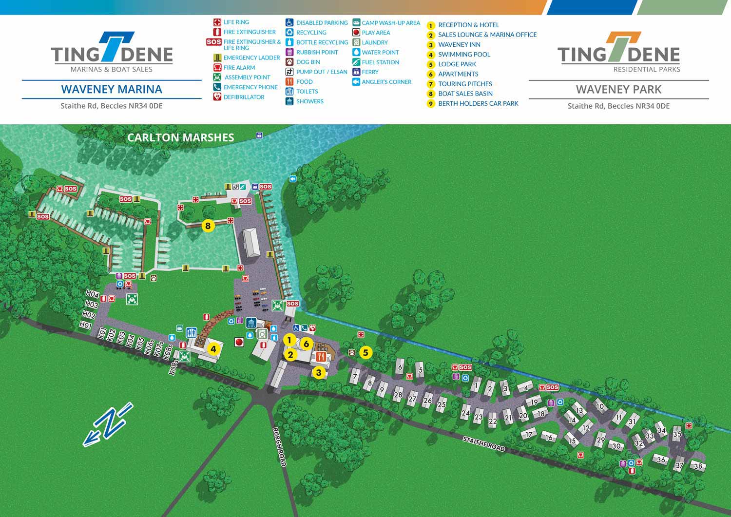
Waveney Marina and Residential Park is a distinctive waterside destination that combines a full service inland marina with residential homes, rental properties, and short term accommodations. The marina provides secure berths for a wide range of vessels and offers essential amenities including fuel, pump out facilities, showers, and on site food options. Set within The Broads, the property benefits from a peaceful natural setting while remaining well connected to popular cruising routes and nearby towns.
Escape Key Graphics was commissioned to create an illustrated map that clearly communicates both the layout and the overall character of the marina and residential park. The overhead perspective makes it easy to understand how the marina facilities relate to the surrounding homes and rental units. Slips, buildings, and key features are clearly labeled, allowing guests to quickly orient themselves while reinforcing a cohesive and professional presentation of the property.
This illustrated map functions as a versatile marketing and wayfinding tool. It is used across digital platforms, in printed materials, and as on site signage to help orient visitors upon arrival. By combining visual accuracy with thoughtful illustration, the map supports daily operations, enhances the guest experience, and helps attract new residents and marina users looking for a high quality waterside setting.


WORK FOR TINGDENE - COMBINED MARINA AND RESIDENTIAL PARK MAPS:


PORTFOLIO GALLERIES
- Illustration work: Start with custom illustration and cover design, then view illustrated maps and architectural renderings.
- Fine art: Discover original paintings and drawings, the Custom Halftone Series, and mural projects.
- Design & motion: Check out the graphic design gallery, then move on to motion graphics and animated illustration.
- Maps by sector: I produce illustrated maps for boat shows, resorts, marinas, real estate, transit & parking, towns & cities, parks, and wayfinding systems.
- More creative services: Additional offerings include cover illustration, vehicle wraps, proposal renderings, and street art.
- Artistic methods: My work spans vector art, isometric & axonometric views, traditional painting, black & white illustration, GeoData mapping, overhead perspectives, and halftone effects. Recently I have also begun to utilize AI in some cases.
- Preferred software: I rely on Photoshop, Illustrator, SketchUp Pro, and InDesign, plus Premiere Pro & After Effects for motion projects.