
Transportation and Parking Map for the Palm Beach International Boat Show - 2024
Client: Informa Markets
For event information and to make sure you're seeing the latest map please visit the official site of the boat show.
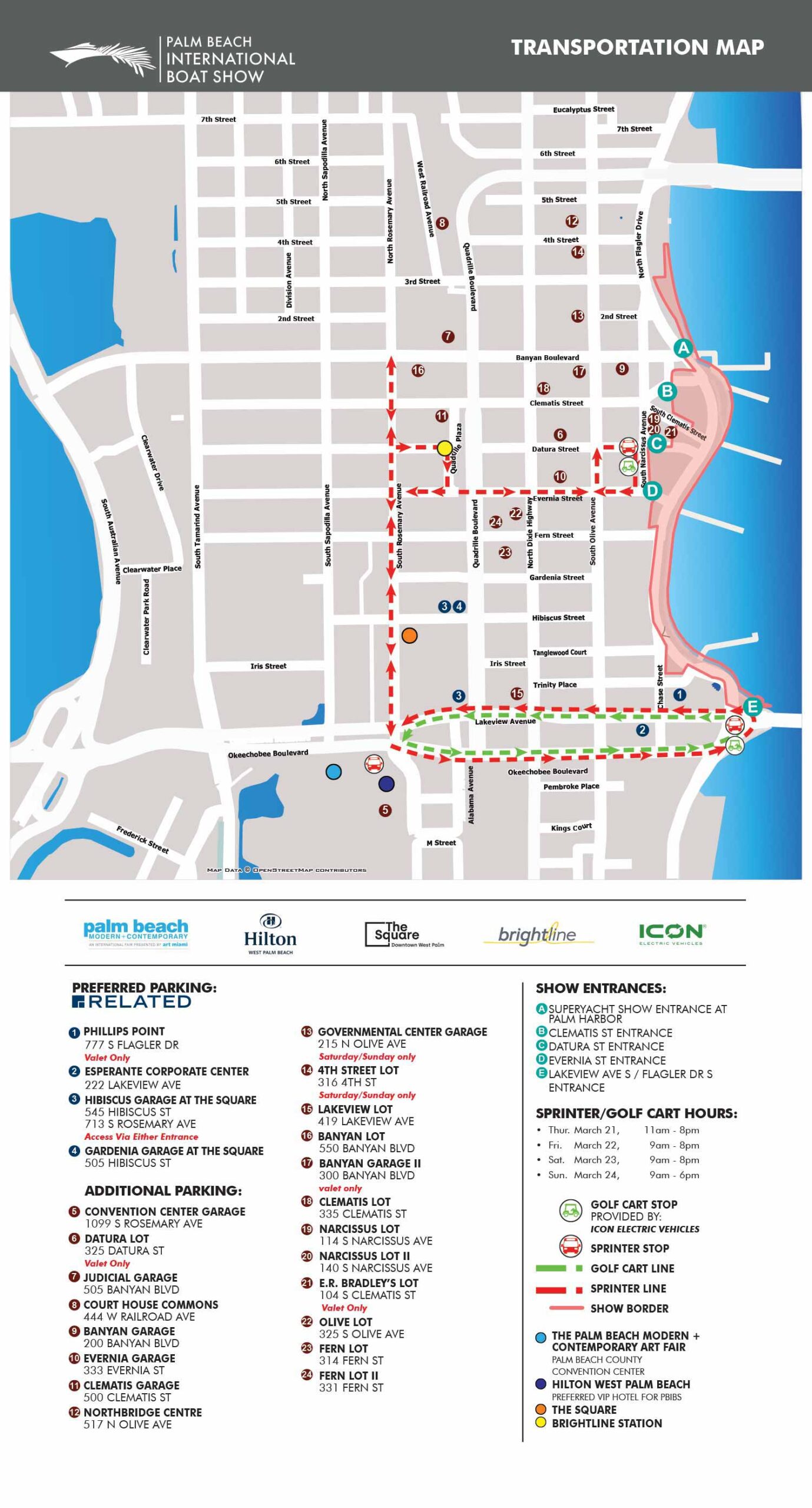
The 2024 Palm Beach International Boat Show transit map continues the commitment to clean, functional design established in recent years. This project serves as a clear example of effective graphic design, where clarity and usability are paramount. The minimalist aesthetic is carefully maintained while integrating the necessary updates for the current event. In spite of increased complexity of services than the previous year the map still looks clean and legible. This is well thought out information density with selective focus.
The transit network saw a key expansion with the addition of a second route. The original route also became more detailed in its path, reflecting actual on street navigation. To clearly distinguish between parking options, "Preferred Parking" was added to the map key, marked with white digits on dark blue dots. General parking facilities continue to be indicated by the established system of white numerals on maroon dots. For further clarity, show entrances are now distinctly keyed using white letters on teal dots.
Terminology was updated, with "trolley" changed to "sprinter" for one service. A new golf cart shuttle service was also added, keyed with a small green graphical icon. The map includes key destinations for visitor planning, listing the Palm Beach Modern and Contemporary Art Show for its second year, as well as the Hilton West Palm Beach, The Square, and the Brightline Station. The map key also clearly explains the show border and the color coding for each transportation route.
This refined map is designed to be an indispensable tool for both pre event planning and onsite navigation, reducing confusion and enhancing the overall attendee experience through thoughtful information design.
Maps For Palm Beach International Boat Show:
- About The Palm Beach Boat Show
- Main Map: 2026 | 2025 | 2024 | 2023 | 2022 | 2021 | 2020 | 2019 | 2018 | 2017 | 2016 | 2015 | 2014 | 2013| 2012 | 2011
- Transit & Parking Map: 2026 | 2025 | 2024 | 2023 | 2022 | 2020 | 2019 | 2018 | 2016
- Program Layout: 2026 | 2025 | 2024
- Video: 2013
BROWSE MY WORK
- Illustration: Browse custom illustrations, book cover art, illustrated maps, and architectural renderings.
- Fine art: View original paintings and drawings, the Custom Halftone Series, and mural commissions.
- Graphic design & motion: See design projects, then watch motion reels and animated pieces.
- Maps by use case: Explore illustrated maps created for boat shows, resorts, marinas, real estate, transportation & parking, cities & towns, parks, and wayfinding.
- Specialty projects: Also check out cover design, vinyl & vehicle wraps, proposal renderings, and street art.
- Style & technique: Discover vector, isometric, painterly, monochrome, data-driven, bird's-eye, and halftone approaches.
- Tools I use: Everyday software includes Photoshop, Illustrator, SketchUp, and InDesign; motion work relies on Premiere & After Effects. Recently I have begun some work using AI as well.