
Map for the Palm Beach International Boat Show - 2023
Client: Informa Markets
For event information please visit the official site of the boat show.
If you are interested in hiring me to create an original map or illustration for you please contact me.
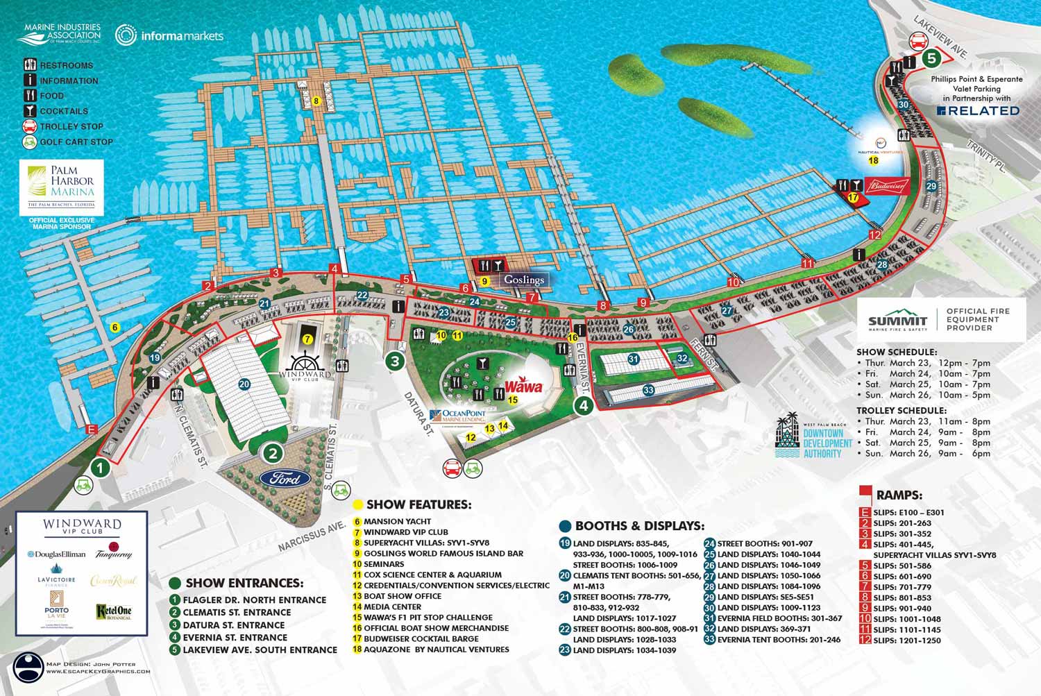

The 2023 Palm Beach International Boat Show utilized a slightly smaller footprint than the previous year, with less of the Palm Harbor Marina in use. This change allowed for a more focused view, enabling me to zoom in closer on the active show areas. The arrangement of the floating docks, which is revised annually, saw a notable change this season with docks extending further into the Lake Worth Lagoon. Additional updates were made to exhibitor tent placements, and the listings within the map key were updated as usual. The overall design, aesthetic, and familiar look of the map were maintained. Relying on the same core three dimensional digital model ensured this visual consistency was easily achieved, providing returning guests with a reliable and recognizable navigational tool.
My process for developing these maps is built on collaboration and attention to detail. The client typically supplies CAD drawings of the planned show layout. I meticulously review these drawings to identify any discrepancies or the client may point them out. Based on this, I update the positions of floating docks, boat silhouettes, and exhibitor tents within the three dimensional digital model that functions as my master file. The client then reviews this initial revised map, providing feedback on any overlooked details or areas that require further clarification.
This initial review is usually followed by receiving updated information for the map keys, often provided in a text format, which frequently leads to additional revisions. The event industry is inherently dynamic, where last minute changes are common as new exhibitors finalize their participation and sponsors adjust their plans. It is standard practice for clients to include disclaimers noting that information may be subject to change after materials are printed or published. This fluid working environment is a key reason many illustrators might avoid such projects. Successfully producing accurate boat show maps requires a graphic artist who is not only precise but also efficient and highly adaptable to evolving requirements.
The 2023 map was implemented across multiple platforms to serve attendees. It was featured on the official event website, integrated into the mobile application, adapted into a vertical format for onsite signage, and printed within the official show program. My scope of work for this event also included designing and illustrating maps for the show's transportation network.
Illustrated event maps fulfill a distinct role by enabling potential visitors to clearly visualize the experience ahead of time. Rather than depending on generic stock imagery, guests can examine an accurate and detailed representation of the event's actual layout. These maps effectively communicate the scale and setting of the event while delivering practical information about facilities and amenities, including restroom locations, food and beverage access, and transportation or parking options. As a result, illustrated maps operate as both visually engaging graphics and genuinely informative marketing and planning resources.
For more examples of my illustrative cartography, please visit my Maps Portfolio.
Maps For Palm Beach International Boat Show:
- About The Palm Beach Boat Show
- Main Map: 2026 | 2025 | 2024 | 2023 | 2022 | 2021 | 2020 | 2019 | 2018 | 2017 | 2016 | 2015 | 2014 | 2013| 2012 | 2011
- Transit & Parking Map: 2026 | 2025 | 2024 | 2023 | 2022 | 2020 | 2019 | 2018 | 2016
- Program Layout: 2026 | 2025 | 2024
- Video: 2013


BROWSE MY WORK
- Illustration: Browse custom illustrations, book cover art, illustrated maps, and architectural renderings.
- Fine art: View original paintings and drawings, the Custom Halftone Series, and mural commissions.
- Graphic design & motion: See design projects, then watch motion reels and animated pieces.
- Maps by use case: Explore illustrated maps created for boat shows, resorts, marinas, real estate, transportation & parking, cities & towns, parks, and wayfinding.
- Specialty projects: Also check out cover design, vinyl & vehicle wraps, proposal renderings, and street art.
- Style & technique: Discover vector, isometric, painterly, monochrome, data-driven, bird's-eye, and halftone approaches.
- Tools I use: Everyday software includes Photoshop, Illustrator, SketchUp, and InDesign; motion work relies on Premiere & After Effects. Recently I have begun some work using AI as well.