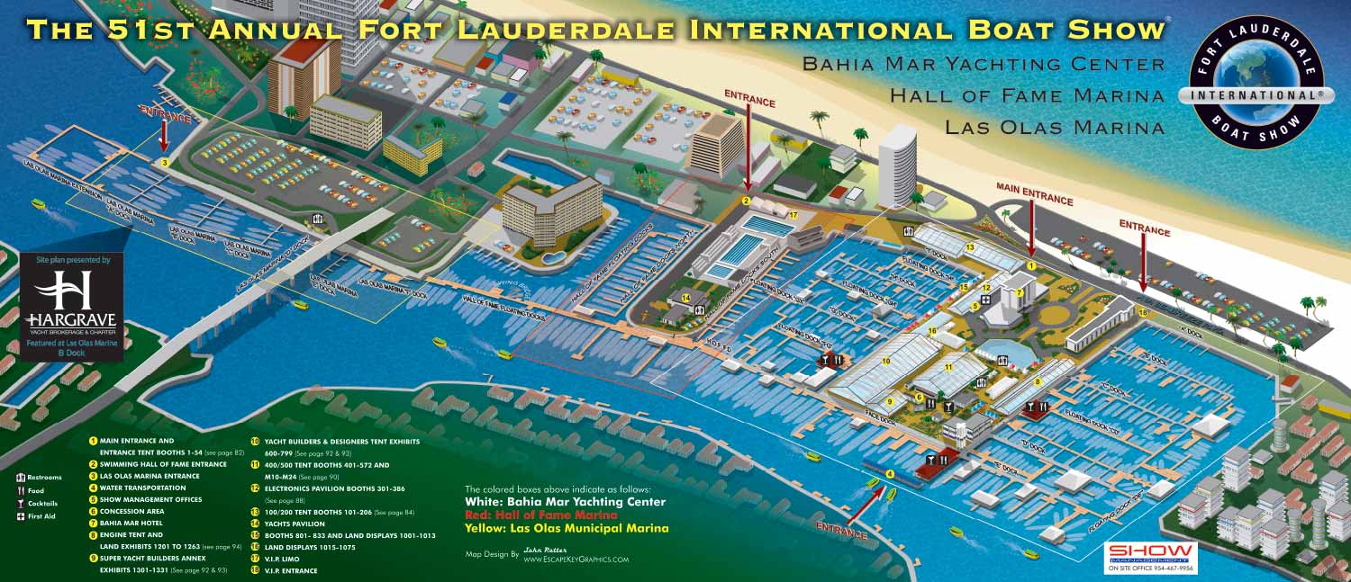
2010 Fort Lauderdale International Boat Show Map
Fort Lauderdale International Boat Show Maps:
- Bahia Mar, Swimming Hall of Fame & Las Olas Marina: 2023 | 2022 | 2020 | 2019 | 2018 | 2017 | 2016 | 2015 | 2014 | 2013 | 2012 | 2011 | 2010
- Transit Maps: 2023 | 2022 | 2020 | 2019 | 2018 | 2015 Bus | 2015 Water Taxi | 2014 | 2013 | 2012 | 2011
- Convention Center: 2023 | 2022 | 2016 | 2015 Ext | 2014 Ext | 2014 | 2013 Ext | 2013 | 2012 | 2011 | 2010
- Marinas Maps: 2023 | 2022 | 2016
- Program Layout: 2023 | 2022
- Signs: 2013 looking north | 2013 Engine Tent
- Video: 2013 54th Annual
- Illustration (not a map): 2014A | 2014B
CUSTOM BOAT SHOW MAPS:


BOAT SHOW MAPS ARTICLE - SOUTHERN BOATING MAGAZINE 2016:
"Navigating Miami’s multiple venues is easier when you use a map. If you’re at Yachts Miami Beach – formerly The Miami Yacht and Brokerage Show – the man behind those maps is John Potter of Escape Key Graphics, who created his first boat show map for the 201 Fort Lauderdale Int’l. Boat Show. It wasn’t long before the creative concept spread. Less intimidating than site plans and more easier to follow than an aerial photography, Potter’s maps now grace the Stuart Boat Show, St. Petersburg Power & Sailboat Show in Florida and International Boat Shows like Newport, Palm Beach and Panama. His work on these shows frequently extends to many maps such as detailed area maps and transit maps. Potter’s maps can also be seen beyond the yachting industry in theme parks, resorts, wildlife sanctuaries, municipalities, campuses and gardens including Flamingo Gardens, Dinosaur World parks or The Dover International Speedway."
AXONOMETRIC AND ISOMETRIC ILLUSTRATIONS:


WHAT ARE AXONOMETRIC AND ISOMETRIC ILLUSTRATIONS?:
Axonometric and isometric drawings don’t have realistic perspective. I use specific mathematical formulas to draw this way. In these images things further away don’t appear smaller and therefore have equal weight of importance to things nearby. My axonometric maps and illustrations are generally bold and have a slightly cartoon like look. This method of rendering perspective is commonly used in technical and engineering drawings. I began using this method of drawing as an illustration tool in 2007.
The difference between isometric and axonometric is isometric drawings are really just from a straight on corner angle but axonometric drawings can be from other angles. Most of my illustrations have parts that are isometric, but are largely axonometric. I have a habit of calling them all isometric, but I shouldn't.
PORTFOLIOS:
- Illustration Portfolio
- Illustrated Maps Portfolio
- Fine Art
- Graphic Design Portfolio
- Motion Design
- Animated Illustrations
- Murals
- Architectural Rendering Portfolio
- Posters Portfolio
By Software Used:
By Application or Use:
- Boat Show Map Portfolio
- Resort Map Illustrations Portfolio
- Marina Maps Portfolio
- Transit, Parking and Transportation Maps Portfolio
- Town and City Maps Portfolio
- Cover Illustration Portfolio
- Vehicle Wrap & Vinyl Wrap Portfolio
- Illustrated Park Maps Portfolio
- Wayfinding Maps Portfolio
- Proposal Renderings Portfolio
- Street Art
- Real Estate Maps Portfolio