
A parking map for a resort in the Florida Keys
Art Direction: Claire Kunzman - Anything But Advertising
For information on Lime Tree Bay Resort please visit their official site.
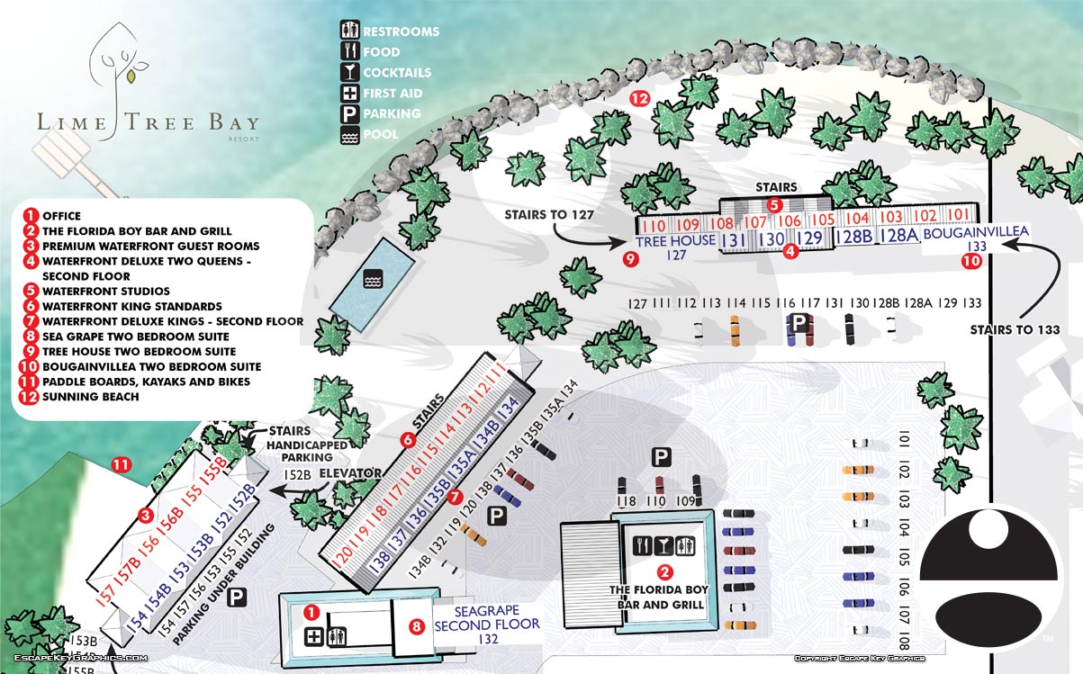
This overhead illustrated map was created for Lime Tree Bay Resort in the Florida Keys to support guest wayfinding and enhance the overall visitor experience. The resort spans a relaxed waterfront property with multiple rental suites, amenities, and shared spaces, making a clear and approachable map an important tool for guests arriving for the first time. The overhead perspective provides an instantly familiar view that helps visitors understand the layout of the property at a glance.
The map combines clean cartographic clarity with light illustration to keep it both functional and visually inviting. Guest suites are clearly identified, allowing visitors to locate their accommodations quickly without confusion. Key points of interest such as the on site restaurant, pool areas, parking, and other essential amenities are marked with simple, intuitive icons. This balance of accuracy and illustration helps guests navigate confidently while reinforcing the laid back character of the resort.
Overhead resort maps like this are especially effective in hospitality settings where guests may be arriving after long travel days and want information that is easy to read and immediately useful. By reducing the need for staff to give repeated directions, the map also supports operational efficiency while improving guest satisfaction. It can be used across multiple formats including printed welcome materials, signage, and digital platforms.
This project reflects my approach to creating custom illustrated maps for resorts, hotels, and vacation properties throughout Florida and beyond. A well designed map not only helps guests find their way, but also becomes part of the brand experience. For resorts and rental properties looking to improve wayfinding while presenting a polished and welcoming image, illustrated overhead maps are a practical and effective solution.


BROWSE MY WORK
- Illustration: Browse custom illustrations, book cover art, illustrated maps, and architectural renderings.
- Fine art: View original paintings and drawings, the Custom Halftone Series, and mural commissions.
- Graphic design & motion: See design projects, then watch motion reels and animated pieces.
- Maps by use case: Explore illustrated maps created for boat shows, resorts, marinas, real estate, transportation & parking, cities & towns, parks, and wayfinding.
- Specialty projects: Also check out cover design, vinyl & vehicle wraps, proposal renderings, and street art.
- Style & technique: Discover vector, isometric, painterly, monochrome, data-driven, bird's-eye, and halftone approaches.
- Tools I use: Everyday software includes Photoshop, Illustrator, SketchUp, and InDesign; motion work relies on Premiere & After Effects. Recently I have begun some work using AI as well.