
Museum Park Map for the Miami International Boat Show - 2024
Client: Informa Markets
For information about the Miami International Boat Show and to ensure you're seeing the latest maps and information visit MiamiBoatShow.com
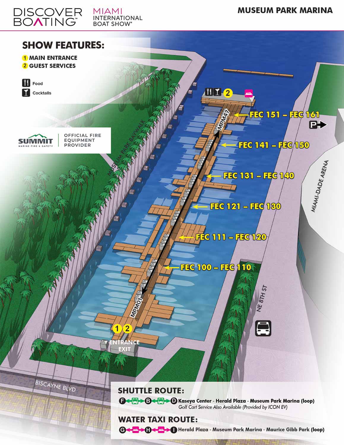
This map illustrates the distinctive marina located between the Kaseya Center, home to the Miami Heat, and Maurice A. Ferré Park (commonly referred to as Museum Park). The marina is notable for its configuration, which typically does not use traditional floating docks. Instead, it features side to mooring capable of accommodating a wide range of vessels, from 100 feet to over 500 feet in length. The site holds historical significance as the original location of the Port of Miami, which operated here from the early 1900s until its relocation to Dodge Island in the 1960s.
The map is designed for immediate clarity and utility. All docks are labeled directly on the illustration for quick identification. Specific show features and points of interest are clearly keyed, while amenities are indicated using a set of intuitive graphical icons. The single relevant shuttle route connecting the area is explained through a simple, straightforward graphical system.
This map was produced as one of five coordinated maps for the event. All were integrated into the official show program, a process that included my completion of the final page layouts to ensure a cohesive visual presentation. Beyond print, the map was utilized across digital platforms, adapted for onsite signage, and incorporated into broader marketing materials.
For an event of this scale and prestige, a clear and professionally designed wayfinding map is not a luxury but an essential component of the visitor experience. It functions on two critical levels: first, as an indispensable practical navigation tool that guides thousands of attendees; and second, as a visual signal of the event's organization, professionalism, and commitment to quality. A well executed map sets a tone of competence and care before a guest even steps onto the docks.
Miami International Boat Show Maps 2024:
Venetian Marina and One Herald Plaza | Museum Park | Miami Beach Convention Center Map | Transportation Map | Pride Park Map | Program LayoutEXAMPLES OF MAPS CREATED FOR MIAMI BOAT SHOWS:


Maps For Boat Shows In Miami:
- About Miami Boat Shows
- Miami International Boat Show / Miami Yacht Show / Yachts Miami Beach / Miami Beach Yacht and Brokerage Show - Show Center/Primary Venue Maps: 2026 | 2025 | 2024 | 2023 | 2022 | 2020 | 2019 | 2018 | 2017 | 2016 | 2015 | 2014 | 2013 | 2012 | 2011
- Transportation Map: 2026 | 2025 | 2024 | 2023 | 2022 | 2020 | 2019 | 2016 | 2013 | 2012
- Program Layout: 2026 | 2025 | 2024 | 2023 | 2022
- Yacht Haven Grande at Island Gardens: 2026 | 2022 | 2020 | 2016
- Miami Beach Convention Center: 2026 | 2025 | 2024 | 2023 | 2022 | 2013 | 2012
- Sea Isle Marina Only: 2013 | 2012
- Miamarina at Bayside Only: 2013 | 2012 | 2011
- Bayfront Park: 2015
- Museum Park Marina: 2025 | 2024 | 2023 | 2022
- Illustration (not a map): 2014
- Video: 2013


EXPLORE MY WORK
- Illustration: Discover custom illustrations, book covers, illustrated maps, and architectural renderings.
- Fine Art: Browse original paintings and drawings, view the Custom Halftone Series, or check out mural projects.
- Graphic Design & Motion: See the graphic design collection, then dive into motion design and animated illustrations.
- Maps by industry: View illustrated maps tailored for boat shows, resorts, marinas, real estate, transportation, towns, parks, and wayfinding.
- More project types: Explore cover art, vehicle wraps, proposal renderings, and street art.
- Techniques & styles: Work spans vector, isometric, painting, black-and-white, GeoData, overhead maps, and halftones.
- Software expertise: Primary tools include Photoshop, Illustrator, SketchUp Pro, and InDesign, plus Premiere Pro & After Effects for motion. I am also supplementing some projects with AI.