
Map for the 2015 Progressive Strictly Sail Miami Boat Show
Client: National Marine Manufacturers Association
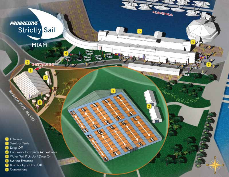
I created this map for the 2015 Progressive Strictly Sail Miami Boat Show. It turned out to be a one time project rather than an annual assignment, which was a little disappointing because I enjoyed the work. Still, it was a fun and interesting challenge while it lasted. I still have the original three dimensional model on file, so if a similar project comes up in the future I would be able to hit the ground running.
The venue was Bayfront Park, right in front of Bayside Marketplace and Miamarina. For those of us who live in South Florida, we generally just call the whole area Bayside. The client had a large exhibitor's tent set up on the grounds, and they wanted guests to be able to orient themselves within the larger area while also finding specific exhibitors inside the main tent by number.
The site had an odd shape that left a large dead space in the middle of the image. I also needed to show details inside the main tent that were too small to see at the scale required for the full area. I solved both problems at once by using that dead space for an inset map. That inset zoomed in on the main tent, giving guests a clear view of exhibitor locations without sacrificing the overall orientation view.
How I Made It
I built the map by creating a three dimensional digital model of the area and rendering it from the chosen angle. Those renderings went into Photoshop for refinement and retouching. After that, I added graphics in Adobe Illustrator, including the numbered key that helped visitors locate specific exhibitors.
The finished map pulled double duty. It worked as a marketing piece online and as a practical wayfinding tool in print. Guests could look at it before they arrived to get a sense of the layout, and they could carry it with them to navigate the show once they were there.
Your Bayside Map Project
If you need a similar map for an event at Bayside, or any other venue that requires both orientation and detail, contact me. I have done this work before, I still have the model ready to go, and I would be glad to do it for you.
Which Miami Boat Show is this?:
Here is all you need to know... I have been making maps for boat shows in Miami since 2011 and in that time a lot has changed. There have been multiple simultaneous shows, show names have changed and now shows have merged. The assorted show titles used have been Miami International Boat Show, Miami Yacht Show, Yachts Miami Beach, Miami Beach Yacht and Brokerage Show and this doesn't include subsections of the shows like Sea Isle Marina, Museum Park Marina and Strictly Sail Miami at Miamarina Bayside. These shows have been managed by different, sometimes competing, management companies. At some point I have been commissioned to make maps for all of them. I'm not going to try to sort this into a comprehensible timeline or anything like that.
I've endeavored to make the maps easy to find but you may find some hidden gems on my site if you dig. Please enjoy these maps for what they are without getting too distracted by the sequence or sponsors/management companies etc.
Maps For Boat Shows In Miami:
- About Miami Boat Shows
- Miami International Boat Show / Miami Yacht Show / Yachts Miami Beach / Miami Beach Yacht and Brokerage Show - Show Center/Primary Venue Maps: 2026 | 2025 | 2024 | 2023 | 2022 | 2020 | 2019 | 2018 | 2017 | 2016 | 2015 | 2014 | 2013 | 2012 | 2011
- Transportation Map: 2026 | 2025 | 2024 | 2023 | 2022 | 2020 | 2019 | 2016 | 2013 | 2012
- Program Layout: 2026 | 2025 | 2024 | 2023 | 2022
- Yacht Haven Grande at Island Gardens: 2026 | 2022 | 2020 | 2016
- Miami Beach Convention Center: 2026 | 2025 | 2024 | 2023 | 2022 | 2013 | 2012
- Sea Isle Marina Only: 2013 | 2012
- Miamarina at Bayside Only: 2013 | 2012 | 2011
- Bayfront Park: 2015
- Museum Park Marina: 2025 | 2024 | 2023 | 2022
- Illustration (not a map): 2014
- Video: 2013
EXAMPLES OF MAPS CREATED FOR MIAMI BOAT SHOWS:


EXPLORE MY WORK
- Illustration: Discover custom illustrations, book covers, illustrated maps, and architectural renderings.
- Fine Art: Browse original paintings and drawings, view the Custom Halftone Series, or check out mural projects.
- Graphic Design & Motion: See the graphic design collection, then dive into motion design and animated illustrations.
- Maps by industry: View illustrated maps tailored for boat shows, resorts, marinas, real estate, transportation, towns, parks, and wayfinding.
- More project types: Explore cover art, vehicle wraps, proposal renderings, and street art.
- Techniques & styles: Work spans vector, isometric, painting, black-and-white, GeoData, overhead maps, and halftones.
- Software expertise: Primary tools include Photoshop, Illustrator, SketchUp Pro, and InDesign, plus Premiere Pro & After Effects for motion. I am also supplementing some projects with AI.