
Museum Park Map for the Miami International Boat Show - 2025
Client: Informa U.S. Boat Shows
For information about the Miami International Boat Show and to ensure you're seeing the latest maps and information visit MiamiBoatShow.com
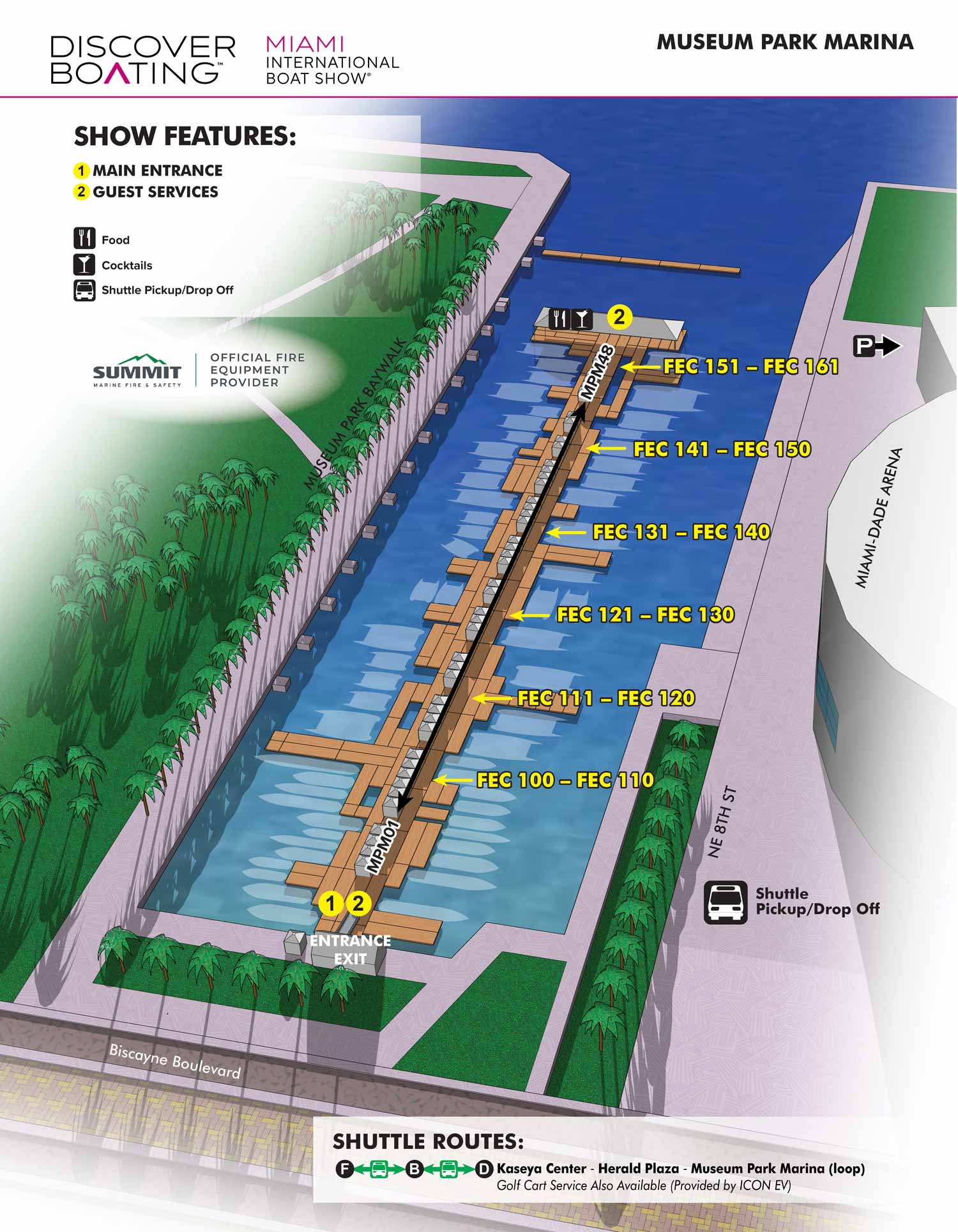
This map is of a marina between the Kaseya Center where the Miami Heat plays and Maurice A. Ferré Park (although you frequently hear it called Museum Park). Normally this marina doesn't sport floating docks, but side to mooring accommodating vessels from 100 feet to over 500 feet. This marina was Port of Miami (early 1900s-1960s) before the port moved to Dodge Island.
Docks are labeled directly on the illustration, show features are keyed and amenities are keyed using graphical icons. The one, relevant shuttle route is graphicly explained with a simple straightforward system. This map was produced alongside four additional maps, all of which were included in the official show program, including page layout work completed by me. The map was also used across digital platforms, on site signage, and broader marketing materials. At an event of this scale, a clear and well designed wayfinding map is essential. It functions not only as a practical navigation tool, but also as a visual signal of organization, professionalism, and overall event quality.
Miami International Boat Show Maps 2025:
Venetian Marina and One Herald Plaza | Museum Park | Miami Beach Convention Center Map | Transportation Map | Pride Park Map | Program LayoutMaps For Boat Shows In Miami:
- About Miami Boat Shows
- Miami International Boat Show / Miami Yacht Show / Yachts Miami Beach / Miami Beach Yacht and Brokerage Show - Show Center/Primary Venue Maps: 2026 | 2025 | 2024 | 2023 | 2022 | 2020 | 2019 | 2018 | 2017 | 2016 | 2015 | 2014 | 2013 | 2012 | 2011
- Transportation Map: 2026 | 2025 | 2024 | 2023 | 2022 | 2020 | 2019 | 2016 | 2013 | 2012
- Program Layout: 2026 | 2025 | 2024 | 2023 | 2022
- Yacht Haven Grande at Island Gardens: 2026 | 2022 | 2020 | 2016
- Miami Beach Convention Center: 2026 | 2025 | 2024 | 2023 | 2022 | 2013 | 2012
- Sea Isle Marina Only: 2013 | 2012
- Miamarina at Bayside Only: 2013 | 2012 | 2011
- Bayfront Park: 2015
- Museum Park Marina: 2025 | 2024 | 2023 | 2022
- Illustration (not a map): 2014
- Video: 2013
EXAMPLES OF MAPS CREATED FOR MIAMI BOAT SHOWS:


EXPLORE MY WORK
- Illustration: Discover custom illustrations, book covers, illustrated maps, and architectural renderings.
- Fine Art: Browse original paintings and drawings, view the Custom Halftone Series, or check out mural projects.
- Graphic Design & Motion: See the graphic design collection, then dive into motion design and animated illustrations.
- Maps by industry: View illustrated maps tailored for boat shows, resorts, marinas, real estate, transportation, towns, parks, and wayfinding.
- More project types: Explore cover art, vehicle wraps, proposal renderings, and street art.
- Techniques & styles: Work spans vector, isometric, painting, black-and-white, GeoData, overhead maps, and halftones.
- Software expertise: Primary tools include Photoshop, Illustrator, SketchUp Pro, and InDesign, plus Premiere Pro & After Effects for motion. I am also supplementing some projects with AI.