
2024 Fort Lauderdale International Boat Show Map: Streamlining for a Full-Scale Return
Client: Informa Markets
For information about the Fort Lauderdale International Boat Show visit FLIBS.com.
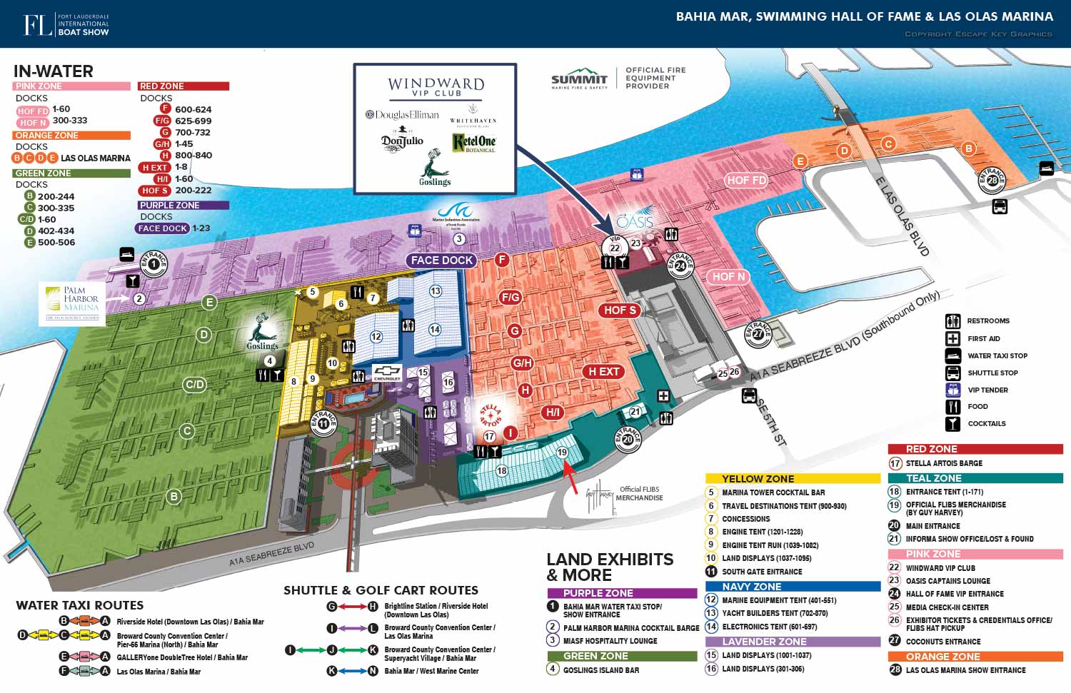


The 2024 Fort Lauderdale International Boat Show (FLIBS) map reflects the event's robust return to its pre-pandemic scale. This year’s illustration involved the essential updates to dock configurations and exhibitor locations, while also incorporating thoughtful refinements to the production workflow and visual design. A key change was the strategic decision to exclude the colored outlines that had previously defined each zone on the map. While a subtle visual adjustment for the end user, this modification significantly streamlined the revision process, allowing for faster and more efficient updates to the expansive show layout.
A major update for 2024 was the full reintegration of the northern section of Las Olas Marina, signaling the show's complete recovery and growth. This expansion required a technical adjustment: rendering the detailed digital 3D model from a slightly different angle and zoom level to accommodate the larger footprint. This flexibility underscores the advantage of a virtual modeling workflow, where the core asset can be easily adapted to reflect physical changes without the need to start from scratch.
Consistent Navigation, Expanded Reach
The navigation system retained the established look, feel, and intuitive methodology of recent years, ensuring continuity for returning attendees. The map’s utility was broader than ever, deployed across multiple critical touchpoints. It served as the central two-page spread in the printed show program, appeared on environmental signage throughout the venues, and was featured in local newspapers. Its digital applications were equally comprehensive, with versions optimized for the official show website, the mobile app, and vertical-format signs.
The project scope for 2024 was extensive. Beyond the main map, I created a total of four distinct maps, some delivered in multiple formats, along with five dedicated signs. I also handled the complete page layout for the official show program, ensuring a cohesive visual identity across all print materials. This holistic approach demonstrates how custom illustration and integrated graphic design work in concert to support the complex needs of a world-class event, from attendee wayfinding to brand presentation.
This project continues a long-standing collaboration. For context on the evolution of this map series, you can explore the 2022 FLIBS Illustrated Map.
To see more examples of large-scale event cartography and publication design, please visit my full Map Portfolio.
Fort Lauderdale International Boat Show Maps 2024:
Bahia Mar, Swimming Hall of Fame & Las Olas Marina Map | Transit and Parking Map | Marinas (17th St Cswy) Map | Broward County Convention Center Map | Program LayoutFort Lauderdale International Boat Show Maps:
- About Fort Lauderdale International Boat Show
- Bahia Mar, Swimming Hall of Fame & Las Olas Marina Maps: 2025 | 2024 | 2023 | 2022 | 2020 | 2019 | 2018 | 2017 | 2016 | 2015 | 2014 | 2013 | 2012 | 2011 | 2010
- Parking and Transportation Maps: 2026 | 2025 | 2024 | 2023 | 2022 | 2020 | 2019 | 2018 | 2015 Bus | 2015 Water Taxi | 2014 | 2013 | 2012 | 2011
- Broward County Convention Center Maps: 2026 | 2025 | 2024 | 2023 | 2022 | 2017 Sailfish Pavilion | 2017 | 2016 Sailfish Pavilion | 2016 | 2015 Sailfish Pavilion | 2015 | 2014 Sailfish Pavilion | 2014 | 2013 Sailfish Pavilion | 2013 | 2012 | 2011 | 2010
- 17th St Marinas Maps: 2026 | 2025 | 2024 | 2023 | 2022 | 2019 | 2016
- Show Directory Layouts: 2025 | 2024 | 2023 | 2022
- Video: 2013 54th Annual
- Illustrations (not maps): 2014A | 2014B
EXPLORE MY WORK
- Illustration: Discover custom illustrations, book covers, illustrated maps, and architectural renderings.
- Fine Art: Browse original paintings and drawings, view the Custom Halftone Series, or check out mural projects.
- Graphic Design & Motion: See the graphic design collection, then dive into motion design and animated illustrations.
- Maps by industry: View illustrated maps tailored for boat shows, resorts, marinas, real estate, transportation, towns, parks, and wayfinding.
- More project types: Explore cover art, vehicle wraps, proposal renderings, and street art.
- Techniques & styles: Work spans vector, isometric, painting, black-and-white, GeoData, overhead maps, and halftones.
- Software expertise: Primary tools include Photoshop, Illustrator, SketchUp Pro, and InDesign, plus Premiere Pro & After Effects for motion. I am also supplementing some projects with AI.