
Fort Lauderdale International Boat Show 2024 - Marinas Map
Client: Informa Markets
For more (and more up to date) information about the 2024 Fort Lauderdale International Boat Show visit their official site at FLIBS.com.
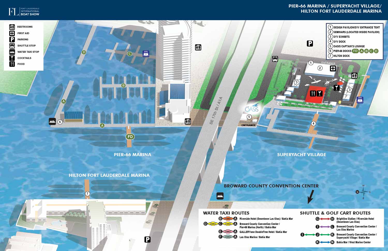
Navigational Clarity for the 2024 Fort Lauderdale International Boat Show
The 2024 Fort Lauderdale International Boat Show marinas map maintains the trusted and effective visual identity developed over previous years. This deliberate consistency provides returning attendees with immediate familiarity, while its clear illustrative style ensures first time visitors can navigate with ease. The annual task involves integrating precise updates that reflect the evolving site plans, from adjustments to dock assignments and land exhibits to the complete reconfiguration of the exclusive Superyacht Village, where luxury exhibitor tents and displays like showcased cars or helicopters are newly positioned each season.
This reliable accuracy is powered by our proprietary three dimensional digital model. This comprehensive master file, cultivated and updated over many years, acts as the central geographic database for the event. Employing this single source guarantees that every derived map, from the primary guide to partner specific versions, shares an identical foundation of accurate spatial data. In 2024, this same model was used to generate a bespoke map for Global Marine Travel, providing them with a cohesive and geographically precise tool for their own marketing and client wayfinding.
Intuitive Design with Clear Map Keys
The map is designed for instant comprehension. Primary venues are prominently labeled directly on the artwork, including Pier Sixty-Six Marina, the Superyacht Village, the Hilton Fort Lauderdale Marina, and the iconic 17th Street Causeway bridge. The map key system was refined for 2024, using numbered black on white dots to clearly indicate specific points of interest. A separate map key featuring intuitive graphical icons continues to identify general amenities across the site. A significant functional upgrade was made to the transportation guide; the graphical key explaining shuttle, golf cart, and water taxi routes was expanded to detail all major routes for the entire show, offering a more complete picture of attendee mobility beyond just the immediate venues illustrated.
A Dual Purpose Asset: From Marketing to Wayfinding
The fundamental purpose of this map is as an onsite navigational instrument. It successfully guides a large audience through various formats, including printed programs, environmental signage, and mobile applications. Its illustrated format is particularly effective, translating intricate physical layouts into an accessible and visually engaging guide.
Yet its strategic application begins well before the event opens. In promotional phases, this detailed map serves as a substantial marketing asset. It offers a meaningful alternative to generic stock imagery by providing future attendees with valuable, concrete information about the event's scale and organization. This tangible preview helps build anticipation, facilitates personal itinerary planning, and can effectively drive participation by visually communicating the substance of the experience.
Allow us to transform the complex logistics of your venue or event into a polished, practical, and versatile visual tool. An Escape Key Graphics map functions as a cornerstone of event communication, effectively serving both promotional objectives and operational needs from initial announcement through to the final attendee departure.
Fort Lauderdale International Boat Show Maps 2024:
Bahia Mar, Swimming Hall of Fame & Las Olas Marina Map | Transit and Parking Map | Marinas (17th St Cswy) Map | Broward County Convention Center Map | Program LayoutFort Lauderdale International Boat Show Maps:
- About Fort Lauderdale International Boat Show
- Bahia Mar, Swimming Hall of Fame & Las Olas Marina Maps: 2025 | 2024 | 2023 | 2022 | 2020 | 2019 | 2018 | 2017 | 2016 | 2015 | 2014 | 2013 | 2012 | 2011 | 2010
- Parking and Transportation Maps: 2026 | 2025 | 2024 | 2023 | 2022 | 2020 | 2019 | 2018 | 2015 Bus | 2015 Water Taxi | 2014 | 2013 | 2012 | 2011
- Broward County Convention Center Maps: 2026 | 2025 | 2024 | 2023 | 2022 | 2017 Sailfish Pavilion | 2017 | 2016 Sailfish Pavilion | 2016 | 2015 Sailfish Pavilion | 2015 | 2014 Sailfish Pavilion | 2014 | 2013 Sailfish Pavilion | 2013 | 2012 | 2011 | 2010
- 17th St Marinas Maps: 2026 | 2025 | 2024 | 2023 | 2022 | 2019 | 2016
- Show Directory Layouts: 2025 | 2024 | 2023 | 2022
- Video: 2013 54th Annual
- Illustrations (not maps): 2014A | 2014B


PORTFOLIO GALLERIES
- Illustration work: Start with custom illustration and cover design, then view illustrated maps and architectural renderings.
- Fine art: Discover original paintings and drawings, the Custom Halftone Series, and mural projects.
- Design & motion: Check out the graphic design gallery, then move on to motion graphics and animated illustration.
- Maps by sector: I produce illustrated maps for boat shows, resorts, marinas, real estate, transit & parking, towns & cities, parks, and wayfinding systems.
- More creative services: Additional offerings include cover illustration, vehicle wraps, proposal renderings, and street art.
- Artistic methods: My work spans vector art, isometric & axonometric views, traditional painting, black & white illustration, GeoData mapping, overhead perspectives, and halftone effects. Recently I have also begun to utilize AI in some cases.
- Preferred software: I rely on Photoshop, Illustrator, SketchUp Pro, and InDesign, plus Premiere Pro & After Effects for motion projects.