
2023 Fort Lauderdale International Boat Show: Broward County Convention Center Map
Client: Informa Markets
Broward County Convention Center Map for the 2023 Fort Lauderdale International Boat Show. Visit their official site at FLIBS.com for information on the show and more up to date information.
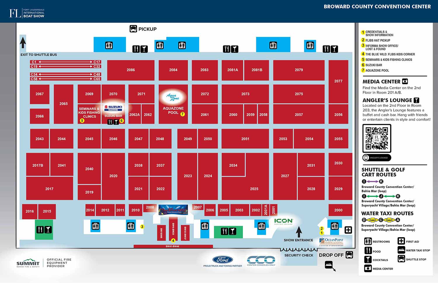
The 2023 Fort Lauderdale International Boat Show map for the Broward County Convention Center represents a refined update to the established design introduced the previous year. Its continued use is a direct testament to the 2022 map's effectiveness in meeting the practical needs of exhibitors and attendees. For this specific venue, a clean, overhead diagrammatic style is the most functional choice. The convention center's primary exhibition hall is largely one contiguous space without a complex internal floorplan, making a detailed architectural rendering unnecessary. The core purpose of this map is to enable guests to quickly locate specific exhibitors by their assigned booth numbers, prioritizing clarity and immediate readability above all else.
This map functions as the central visual reference alongside a corresponding alphabetical list of exhibitors and their numbers, a pairing featured in the official show program and on directional signage throughout the venue.
Clarity Through Consistent Design and a Unified Map Legend
The visual system remained consistent to ensure user familiarity. The main convention center floor is represented as a light blue field, with each exhibitor's space distinctly outlined by a bold red rectangle. These spaces are accurately labeled with individual numbers or number ranges for precise identification.
All navigational information is consolidated into a single, well organized sidebar. This unified map legend is a key factor in the design's uncluttered and professional appearance. Within this sidebar, a system of yellow dots with black text efficiently denotes key points of interest, such as restrooms, information desks, and entry points. Furthermore, a graphical representation of all available shuttle routes is included in this area, providing a clear overview of transportation connections directly on the map.
Versatile Application Across Platforms
This map served as a versatile asset throughout the 2023 event. It was featured in print within the official show program, displayed on large format signage for onsite orientation, integrated into the event's website, and optimized for use within the official mobile application. Its clean and informative design also made it suitable for general marketing and promotional purposes in the lead-up to the show, providing a clear preview of the convention center's layout.
This project highlights our ability to create highly functional informational graphics that serve multiple roles, from pre-event planning tools to essential onsite navigational aids. By focusing on the user's primary need, efficient wayfinding, we deliver maps that are both practical and polished.
For more examples of our tailored cartography and graphic design solutions for complex events, please visit our Maps Portfolio.
Fort Lauderdale International Boat Show Maps:
- About Fort Lauderdale International Boat Show
- Bahia Mar, Swimming Hall of Fame & Las Olas Marina Maps: 2025 | 2024 | 2023 | 2022 | 2020 | 2019 | 2018 | 2017 | 2016 | 2015 | 2014 | 2013 | 2012 | 2011 | 2010
- Parking and Transportation Maps: 2026 | 2025 | 2024 | 2023 | 2022 | 2020 | 2019 | 2018 | 2015 Bus | 2015 Water Taxi | 2014 | 2013 | 2012 | 2011
- Broward County Convention Center Maps: 2026 | 2025 | 2024 | 2023 | 2022 | 2017 Sailfish Pavilion | 2017 | 2016 Sailfish Pavilion | 2016 | 2015 Sailfish Pavilion | 2015 | 2014 Sailfish Pavilion | 2014 | 2013 Sailfish Pavilion | 2013 | 2012 | 2011 | 2010
- 17th St Marinas Maps: 2026 | 2025 | 2024 | 2023 | 2022 | 2019 | 2016
- Show Directory Layouts: 2025 | 2024 | 2023 | 2022
- Video: 2013 54th Annual
- Illustrations (not maps): 2014A | 2014B


MAPS FOR BOAT SHOWS IN FORT LAUDERDALE:


PORTFOLIO GALLERIES
- Illustration work: Start with custom illustration and cover design, then view illustrated maps and architectural renderings.
- Fine art: Discover original paintings and drawings, the Custom Halftone Series, and mural projects.
- Design & motion: Check out the graphic design gallery, then move on to motion graphics and animated illustration.
- Maps by sector: I produce illustrated maps for boat shows, resorts, marinas, real estate, transit & parking, towns & cities, parks, and wayfinding systems.
- More creative services: Additional offerings include cover illustration, vehicle wraps, proposal renderings, and street art.
- Artistic methods: My work spans vector art, isometric & axonometric views, traditional painting, black & white illustration, GeoData mapping, overhead perspectives, and halftone effects. Recently I have also begun to utilize AI in some cases.
- Preferred software: I rely on Photoshop, Illustrator, SketchUp Pro, and InDesign, plus Premiere Pro & After Effects for motion projects.