
Fort Lauderdale International Boat Show 2022 - Parking and Transit Map
Client: Informa Markets
For more (and more up to date) information about the 2022 Fort Lauderdale International Boat Show visit their official site at 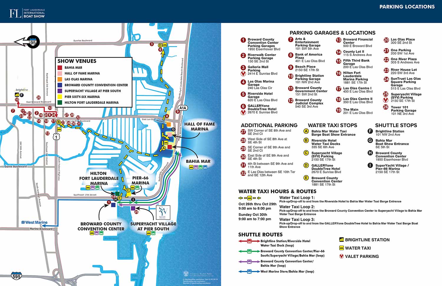
Following the 2021 hiatus, the team at Informa Markets was dedicated to enhancing all aspects of the Fort Lauderdale International Boat Show, including its wayfinding materials. The development of the 2022 transit map felt like a more collaborative and equitable process than in some previous years, with a shared focus on creating a more effective tool for attendees.
Together, we made several key decisions to improve clarity. We agreed to reduce the complexity of the graphical icons, opting for color coded dots or simplified symbols wherever possible. A specific request to remove color from non essential elements, including the green tint previously used for land areas, proved to be excellent advice that significantly cleaned up the visual field. We also removed all depictions of unlabeled roads and other superfluous details. The lines indicating land based transit routes were made much thinner and changed from a dashed to a solid style. Show venues were clearly indicated on the map with clean sans serif type and directional arrows, supplemented by a simple color key of squares that acted as small, consistent venue icons. A major improvement was the treatment of shuttle and water taxi stops; they were keyed with clear icons, but the detailed routes were visually separated, making the boarding points much easier to identify at a glance. Colored lines still showed the general path of the transit system, but they no longer competed visually with the stop locations.
The core keying systems were maintained for user familiarity. Parking was indicated with white numerals on maroon dots, water taxis with black letters on yellow dots, and shuttle stops with white letters on black dots. As mentioned, routes used a separate color key. The Brightline station was marked with a distinct icon. All icons were standardized to a uniform size, creating a more harmonious and professional layout. The entire map and its accompanying menu were designed to fit neatly as a double page spread in the official show program, a publication for which I also handled the page layout starting in 2022.
While the list of parking addresses remained with the map, future editions would remove the dots from the illustration itself, trusting attendees to use the provided addresses with their GPS navigation.
I was very pleased to produce this map. It represents a significant positive evolution, the result of years of iterative refinement and constructive feedback. While no design is perfect, this 2022 edition stands as a clear, functional, and well organized transportation guide. It serves as a reminder that developing effective transit maps is a complex challenge, one that benefits greatly from sustained collaboration and a willingness to simplify.
Fort Lauderdale International Boat Show Maps 2022:
Bahia Mar, Swimming Hall of Fame & Las Olas Marina | Transit and Parking | Marinas (17th St Cswy) | Broward County Convention Center Map | Program Layout


MAPS FOR BOAT SHOWS IN FORT LAUDERDALE:


Fort Lauderdale International Boat Show Maps:
- About Fort Lauderdale International Boat Show
- Bahia Mar, Swimming Hall of Fame & Las Olas Marina Maps: 2025 | 2024 | 2023 | 2022 | 2020 | 2019 | 2018 | 2017 | 2016 | 2015 | 2014 | 2013 | 2012 | 2011 | 2010
- Parking and Transportation Maps: 2026 | 2025 | 2024 | 2023 | 2022 | 2020 | 2019 | 2018 | 2015 Bus | 2015 Water Taxi | 2014 | 2013 | 2012 | 2011
- Broward County Convention Center Maps: 2026 | 2025 | 2024 | 2023 | 2022 | 2017 Sailfish Pavilion | 2017 | 2016 Sailfish Pavilion | 2016 | 2015 Sailfish Pavilion | 2015 | 2014 Sailfish Pavilion | 2014 | 2013 Sailfish Pavilion | 2013 | 2012 | 2011 | 2010
- 17th St Marinas Maps: 2026 | 2025 | 2024 | 2023 | 2022 | 2019 | 2016
- Show Directory Layouts: 2025 | 2024 | 2023 | 2022
- Video: 2013 54th Annual
- Illustrations (not maps): 2014A | 2014B
EXPLORE MY WORK
- Illustration: Discover custom illustrations, book covers, illustrated maps, and architectural renderings.
- Fine Art: Browse original paintings and drawings, view the Custom Halftone Series, or check out mural projects.
- Graphic Design & Motion: See the graphic design collection, then dive into motion design and animated illustrations.
- Maps by industry: View illustrated maps tailored for boat shows, resorts, marinas, real estate, transportation, towns, parks, and wayfinding.
- More project types: Explore cover art, vehicle wraps, proposal renderings, and street art.
- Techniques & styles: Work spans vector, isometric, painting, black-and-white, GeoData, overhead maps, and halftones.
- Software expertise: Primary tools include Photoshop, Illustrator, SketchUp Pro, and InDesign, plus Premiere Pro & After Effects for motion. I am also supplementing some projects with AI.