
Fort Lauderdale International Boat Show 2025 - Parking and Transportation Map
Client: Informa Markets
For more (and more up to date) information about the 2025 Fort Lauderdale International Boat Show visit their official site at FLIBS.com.

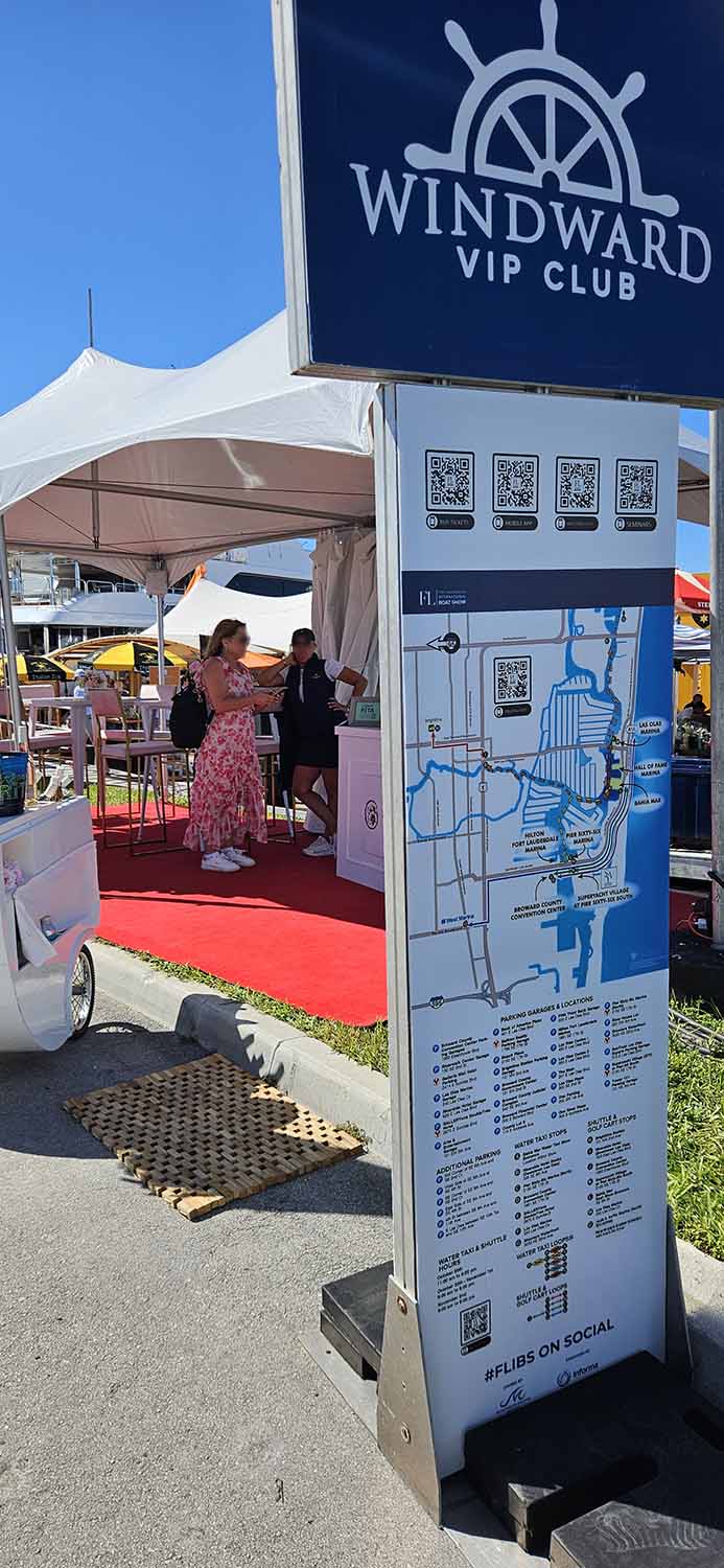
This transportation and parking map for the Fort Lauderdale International Boat Show is built on a foundation of original base mapping developed in 2018. Before that time, FLIBS transportation maps leaned toward a more illustrative style, using angled perspectives and landmark drawings to aid wayfinding. As shuttle routes and water taxi stops expanded over the years, the original single map was eventually split into separate versions for land and water transportation, which made it harder for visitors to quickly understand the full system.
In 2018, the goal shifted toward clarity and consolidation. The map was redesigned as a single, comprehensive resource that could communicate all transportation options at a glance. A direct overhead street view was chosen to remove visual complexity and improve readability. Public domain geographic data from OpenStreetMap was used to ensure a high level of accuracy and flexibility. This data provides access to detailed street information that supports both current needs and future revisions. While the core base map remains largely consistent from year to year, the content is carefully updated to reflect changing routes, stops, and event logistics. The final artwork is fully vector based and produced using a combination of professional design tools.
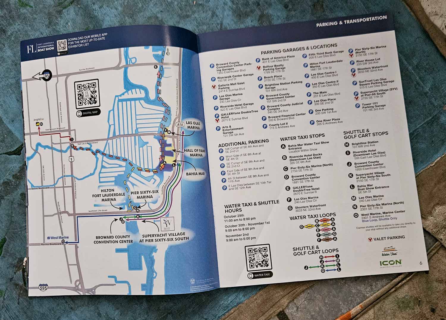
The finished map presents a clean, simplified street layout that highlights only major roads and streets relevant to the boat show. Land areas remain white while roads are shown in neutral gray, allowing transportation routes to stand out clearly. Major highways are labeled with familiar shield graphics, while minor streets use smaller type for readability. Show venues are identified with text and directional callouts. Shuttle and water taxi routes are displayed as color coded lines, with shuttle routes shown as solid paths and water taxi routes shown as dashed paths. Stops are marked with lettered dots that correspond to a clear visual legend, making the map easy to interpret for a wide range of users. Key locations such as Brightline and West Marine stops are reinforced with recognizable logos.
Parking information is presented in a practical, user focused way. Parking locations are listed clearly, with full addresses included to support GPS navigation, while valet parking options are prominently labeled. This map is designed for versatility and is used across multiple platforms, including the official website, a mobile app, on site signage, and the printed show program (page layout by Escape Key Graphics). Its clean structure and consistent visual language make it an effective tool for navigation, communication, and large scale event planning.
Fort Lauderdale International Boat Show Maps 2025:
Bahia Mar, Swimming Hall of Fame & Las Olas Marina Map | Transit and Parking Map | Marinas (17th St Cswy) Map | Broward County Convention Center Map | Program LayoutMAPS FOR BOAT SHOWS IN FORT LAUDERDALE:


Fort Lauderdale International Boat Show Maps:
- About Fort Lauderdale International Boat Show
- Bahia Mar, Swimming Hall of Fame & Las Olas Marina Maps: 2025 | 2024 | 2023 | 2022 | 2020 | 2019 | 2018 | 2017 | 2016 | 2015 | 2014 | 2013 | 2012 | 2011 | 2010
- Parking and Transportation Maps: 2026 | 2025 | 2024 | 2023 | 2022 | 2020 | 2019 | 2018 | 2015 Bus | 2015 Water Taxi | 2014 | 2013 | 2012 | 2011
- Broward County Convention Center Maps: 2026 | 2025 | 2024 | 2023 | 2022 | 2017 Sailfish Pavilion | 2017 | 2016 Sailfish Pavilion | 2016 | 2015 Sailfish Pavilion | 2015 | 2014 Sailfish Pavilion | 2014 | 2013 Sailfish Pavilion | 2013 | 2012 | 2011 | 2010
- 17th St Marinas Maps: 2026 | 2025 | 2024 | 2023 | 2022 | 2019 | 2016
- Show Directory Layouts: 2025 | 2024 | 2023 | 2022
- Video: 2013 54th Annual
- Illustrations (not maps): 2014A | 2014B
EXPLORE MY WORK
- Illustration: Discover custom illustrations, book covers, illustrated maps, and architectural renderings.
- Fine Art: Browse original paintings and drawings, view the Custom Halftone Series, or check out mural projects.
- Graphic Design & Motion: See the graphic design collection, then dive into motion design and animated illustrations.
- Maps by industry: View illustrated maps tailored for boat shows, resorts, marinas, real estate, transportation, towns, parks, and wayfinding.
- More project types: Explore cover art, vehicle wraps, proposal renderings, and street art.
- Techniques & styles: Work spans vector, isometric, painting, black-and-white, GeoData, overhead maps, and halftones.
- Software expertise: Primary tools include Photoshop, Illustrator, SketchUp Pro, and InDesign, plus Premiere Pro & After Effects for motion. I am also supplementing some projects with AI.