Fort Lauderdale International Boat Show SYBAss Marinas Map 2024
Fort Lauderdale International Boat Show SYBAss Marinas Map 2024
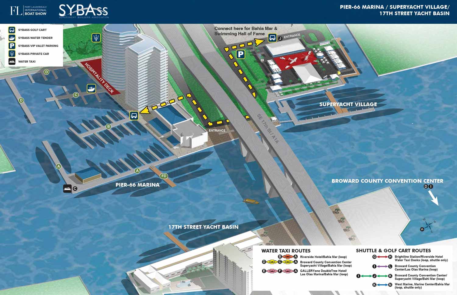
A custom illustrated map for the SYBAss area at the Fort Lauderdale International Boat Show
For all the latest information on SYBAss please visit their site at SYBAss.org.
If you are interested in hiring me to create an original map or illustration for you please contact me.
About the Location
This map covers the three marinas surrounding the 17th Street Causeway Bridge in Fort Lauderdale, Florida. This is one of the busiest and most visible areas during the show, with some of the largest yachts on display.
Basis of This Map
This map, like most of my boat show maps, is built on a digital three dimensional model. I created the original model years ago and update it each year with the new locations of floating docks and exhibitor spaces.
For this version I rendered the model from a different angle than the main show map uses. This gives the SYBAss area its own unique look while keeping the same basic information. I then retouched and refined the image in Photoshop. Finally I added the logos, map key, and all other graphics in Adobe Illustrator.
About This Map
SYBAss, which stands for Superyacht Builders Association, wanted their own version of the main show map I created for Informa Markets. Because I already had the updated three dimensional model, this was a straightforward request.
Normally having a model to work from means I can change the angle, zoom level, or field of view to create a completely custom view. For this map we did exactly that. The angle is different from what Informa has used in recent years, which makes the map feel fresh and specific to the SYBAss area. There were also a few other minor revisions to highlight the features most relevant to their members and guests.
Your Map
If you need a map for a boat show, an event, or any other venue that requires clear, detailed, and visually consistent navigation, contact me. I have done this work before and I would be glad to do it for you.

SYBAss Marinas Map

2025 FLIBS SYBAss Map

PBIBS SYBAss Map
Fort Lauderdale International Boat Show Maps:

Fort Lauderdale International Boat Show Map

Miami International Boat Show 2026

Newport Beach International Boat Show Map

Newport International Boat Show Map

San Diego International Boat Show Map

Sarasota Boat Show Map

Windy City Boat & Yacht Show Map

Boat Show Map

A South American Boat Show Map

Boat Show Illustrated Map

Chicago International Boat Show Map

St. Pete Boat Show Map

Convention Center Map

Transportation Map Using GeoData

Transportation & Parking Map

Illustrated Map of Marinas

Convention Center Map

Yacht Haven Grande Miami

Marina Map

Transit Map

Show Proposal Rendering

Yacht Club Map

Miami International Boat Show 2025

Transportation & Parking Map

Miami Beach Convention Center
PBIBS SYBAss Map
PORTFOLIO GALLERIES
- Illustration work: Start with custom illustration and cover design, then view illustrated maps and architectural renderings.
- Fine art: Discover original paintings and drawings, the Custom Halftone Series, and mural projects.
- Design & motion: Check out the graphic design gallery, then move on to motion graphics and animated illustration.
- Maps by sector: I produce illustrated maps for boat shows, resorts, marinas, real estate, transit & parking, towns & cities, parks, and wayfinding systems.
- More creative services: Additional offerings include cover illustration, vehicle wraps, proposal renderings, and street art.
- Artistic methods: My work spans vector art, isometric & axonometric views, traditional painting, black & white illustration, GeoData mapping, overhead perspectives, and halftone effects. Recently I have also begun to utilize AI in some cases.
- Preferred software: I rely on Photoshop, Illustrator, SketchUp Pro, and InDesign, plus Premiere Pro & After Effects for motion projects.
